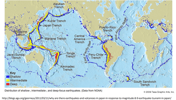
Step 1 see the attached map
Each dot on this map represents a place where earthquakes commonly occur. The color of the dot represents at what depth in Earth's crust the rupture begins: shallow (0 to 70 km), intermediate (70 to 300 km) or deep (300 to 700 km).
Step 2: Annotate this map
Make notes by drawing on the map based on the three types of plate boundaries, which are divergent, convergent, and transform.
Your annotations MUST include at least 5 of the following types of notes:
- a line or set of lines that connect the dots
- a label indicating the type of plate boundary that coincides with a particular group of earthquakes
- a label indicating the type(s) of features that you would expect to find near a particular group of earthquakes
- additional symbols plotted on the map (and in the map key) to indicate the presence of mountains, volcanoes, etc...
- arrows to show the relative direction of plate movement
- observations that relate to your own personal experience with an area shown on this map
- questions or comments
You will want to include at least 10 annotations on the map from at least 5 of the categories bulleted above.
When drawing Do not use the colors purple, orange, or green to annotate on the map

Trending nowThis is a popular solution!
Step by stepSolved in 3 steps with 1 images

 Applications and Investigations in Earth Science ...Earth ScienceISBN:9780134746241Author:Edward J. Tarbuck, Frederick K. Lutgens, Dennis G. TasaPublisher:PEARSON
 Exercises for Weather & Climate (9th Edition)Earth ScienceISBN:9780134041360Author:Greg CarbonePublisher:PEARSON
 Environmental ScienceEarth ScienceISBN:9781260153125Author:William P Cunningham Prof., Mary Ann Cunningham ProfessorPublisher:McGraw-Hill Education
 Earth Science (15th Edition)Earth ScienceISBN:9780134543536Author:Edward J. Tarbuck, Frederick K. Lutgens, Dennis G. TasaPublisher:PEARSON
 Environmental Science (MindTap Course List)Earth ScienceISBN:9781337569613Author:G. Tyler Miller, Scott SpoolmanPublisher:Cengage Learning
 Physical GeologyEarth ScienceISBN:9781259916823Author:Plummer, Charles C., CARLSON, Diane H., Hammersley, LisaPublisher:Mcgraw-hill Education,


