
APPLICATIONS & INVESTIGATIONS EARTH SC
14th Edition
ISBN: 9781269704052
Author: Tarbuck
Publisher: Pearson Custom Publishing
expand_more
expand_more
format_list_bulleted
Textbook Question
Chapter 4.8, Problem 1A
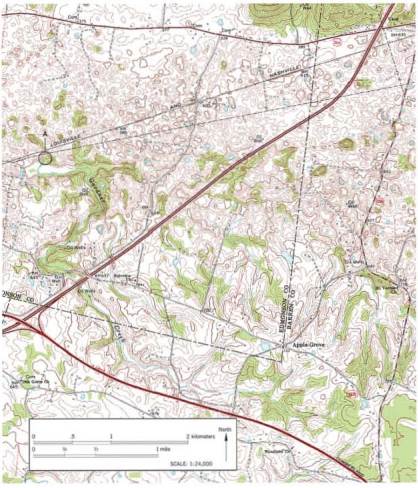
Locate three sinkholes (depressions) on the map and mark each with an X. (Hint: Look for closed contour lines with hachures.)
Expert Solution & Answer

Learn your wayIncludes step-by-step video

schedule09:12
Students have asked these similar questions
Calculate the gradient, or slope, of this portion of the Missouri River by following the steps below:
Step 1: Locate a contour line that crosses the river. Note: An index contour crosses the river in Section 26 (lower left portion of the map). Follow the index contour to the right to establish its elevation.
Elevation: ________ feet
Step 2: Locate a second index contour that crosses the river. Note: Look in Section 11, between the letters V and E in the word RIVER. What is its elevation?
Elevation: ________ feet
Step 3: Use a string and the bar scale to measure the approximate distance (to the nearest mile) between these two index contours.
Distance: ________ feet
Step 4: Calculate the gradient of the river by using the following formula: Gradient Difference in elevation (feet) / Distance (miles)
Gradient: ________ feet per mile
Assume an unsaturated air parcel located at sea level (0 meters) in the SacramentoValley has an initial air temperature of 17°C and a specific humidity of 4kg H2O/kg air.The prevailing westerlies are forcing the air parcel eastward towards the western slopeof the Sierras.a. Calculate the relative humidity and the dew point temperature of the air parcelat 0 meters.
Seismogram A (New York, NY): The time difference between the P-wave and S-wave arrival is approximately 5 minutes, roughly 2000 kilometers.Seismogram B (Nome, Alaska): The time difference between the P-wave and S-wave arrival is approximately 6 minutes, roughly 2900 kilometers.Seismogram C (Mexico City, Mexico): The time difference between the P-wave and S-wave arrival is approximately 4 minutes, roughly 1500 kilometers.
Use Figure 4.6 and a drafting compass to draw a circle around each of the three stations. Make the radius (in miles) of each circle equal to the station's distance from the epicenter as determined above. (Use the scale on the map to set the radius on the drafting compass.) The circles you draw should intersect at approximately one point. This point is the epicenter. If they do not intersect at one point, find a point that is equidistant from the edges of the three circles and use this as the epicenter. Label the epicenter on the map.
Chapter 4 Solutions
APPLICATIONS & INVESTIGATIONS EARTH SC
Ch. 4.1 - Sketch, label, and discuss the hydrologic cycle....Ch. 4.1 - Sketch, label, and discuss the hydrologic cycle....Ch. 4.1 - Prob. 3ACh. 4.1 - Sketch, label, and discuss the hydrologic cycle....Ch. 4.1 - Sketch, label, and discuss the hydrologic cycle....Ch. 4.1 - Prob. 6ACh. 4.2 - Of the three materials you tested coarse sand,...Ch. 4.2 - Prob. 2ACh. 4.2 - Prob. 3ACh. 4.2 - Prob. 4A
Ch. 4.3 - Does urbanization increase or decrease the peak...Ch. 4.3 - What is the effect of urbanization on lag time the...Ch. 4.3 - Does total runoff occur over a longer or shorter...Ch. 4.3 - Prob. 4ACh. 4.4A - Prob. 1ACh. 4.4A - Is the terrain in section 14, located on the west...Ch. 4.4A - Label the areas that topographically resemble...Ch. 4.4A - Describe the topography in the lower half of...Ch. 4.4A - Section 17 contains a portion of the valley...Ch. 4.4A - Which of the following best describes the shape of...Ch. 4.4A - Calculate the gradient, or slope, of this portion...Ch. 4.4A - Approximately how many feet is the Missouri River...Ch. 4.4A - What are the features in the river labeled with...Ch. 4.4A - Based on your answer to Question 9, are the...Ch. 4.4A - Over time, as tributaries erode and lengthen their...Ch. 4.4B - Draw an arrow on the map to indicate the direction...Ch. 4.4B - Prob. 2ACh. 4.4B - Approximately how many feet is the Genesee River...Ch. 4.4B - The path of the Genesee River can best be...Ch. 4.4B - Which phrase most accurately describes most of the...Ch. 4.4B - Prob. 7ACh. 4.4C - Approximately what percentage of the map area is...Ch. 4.4C - Prob. 2ACh. 4.4C - Prob. 3ACh. 4.4C - Prob. 4ACh. 4.4C - Prob. 5ACh. 4.4C - Write a statement that compares the width of the...Ch. 4.4C - Prob. 7ACh. 4.4C - On which of the three maps is the gradient of the...Ch. 4.4C - Prob. 9ACh. 4.5 - Label the zone of saturation, the unsaturated...Ch. 4.5 - Describe the shape of the water table in...Ch. 4.5 - Prob. 3ACh. 4.5 - Use a pencil to shade the area between the dashed...Ch. 4.5 - Prob. 5ACh. 4.6 - Calculate the elevation of the water table at each...Ch. 4.6 - Assume that a dye was put into well A on May 10,...Ch. 4.7 - What is the general relationship between ground...Ch. 4.7 - What was the total ground subsidence, and what was...Ch. 4.7 - During the period shown on the graph, on average,...Ch. 4.7 - Was the ground subsidence that occurred between...Ch. 4.7 - Notice that minimal subsidence occurred from 1935...Ch. 4.8 - Locate three sinkholes depressions on the map and...Ch. 4.8 - Notice that several sinkholes have water in them....Ch. 4.8 - Describe what is happening to Gardner Creek in the...Ch. 4 - Write a statement or two describing the movement...Ch. 4 - Assume that you need to determine the rate at...Ch. 4 - Write a brief paragraph summarizing the results of...Ch. 4 - Prob. 4LRCh. 4 - Prob. 5LRCh. 4 - Name and describe two features you would expect to...Ch. 4 - Prob. 7LRCh. 4 - Assume that you have decided to drill a water...Ch. 4 - Prob. 9LR
Additional Science Textbook Solutions
Find more solutions based on key concepts
Why are the top predators in food chains most severely affected by pesticides such as DDT?
Campbell Essential Biology (7th Edition)
Which one of the following is not a fuel produced by microorganisms? a. algal oil b. ethanol c. hydrogen d. met...
Microbiology: An Introduction
Could an organism be a fermenter and also be both MR and V—P negative? Explain.
Laboratory Experiments in Microbiology (12th Edition) (What's New in Microbiology)
Match each of the following items with all the terms it applies to:
Human Physiology: An Integrated Approach (8th Edition)
Explain why genetic Variation within a population is a prerequisite for evolution.
Campbell Biology (11th Edition)
1.6 Read the labels on products used to wash your dishes. What are the names of some chemicals contained in tho...
Chemistry: An Introduction to General, Organic, and Biological Chemistry (13th Edition)
Knowledge Booster

Similar questions
- Please write the final report in detail with all the components.arrow_forwardProvide two paragraphs on your thoughts of reforestation. Please write in first person.arrow_forward1. Label the zone of saturation, the unsaturated zone, and the water table.2. Describe the shape of the water table in relationship to the shape of the land surface.3. Whenever a substantial amount of water is withdrawn from a well, the water table forms a cone of depression. Label the cone of depression on Figure 8.13. What factors might cause a cone of depression to become larger or smaller?4. Use a pencil to shade the area between the dashed lines labeled A. This zone represents an impermeable lens of clay. Describe what will happen to water that infiltrates to the depth of the clay lens at point A.5. How does the drop in the water table during a drought affect the operation of the well? The blue dashed line in Figure 8.13 represents the level of the water table during a drought.arrow_forward
- PlEaSe HeLp As SoOn As PoSsIbLe Identify and label examples of a point bar, a cutbank, and an oxbow lake on the stereogram in Figure 8.11.arrow_forwardWhich of the following is NOT a natural reservoir for water? trees, lakes, creeks, rivers, atmospherearrow_forward1. Draw an arrow on the map to indicate the direction that the main river, the Genesee, is flowing. (Hint: Use the elevations of the two bench marks [BM] next to the river near the top and bottom of the map to determine your answer.) 2. Use the BM elevations from Question 1 to calculate the approximate gradient of the Genesee River. 3. Use Figure 8.9 to draw a profile along line A-A". Use only index contour lines. 4. Approximately how many feet is the Genesee River above sea level? 5. The path of the Genesee River can best be described as which of the following: a straight course or a meandering course? 6. Which phrase most accurately describes most of the areas beyond the Genesee River Valley: very broad and flat or relatively hilly and dissected? 7. Use the fractional scales on the Angelica topographic map and the Portage, Montana, map (page 136) to answer the following. a. What is the fractional scale for the Angelica map? b. How does this compare to the fractional scale for the…arrow_forward
- 1. Compare the stereogram in Figure 8.7 to the map in Figure 8.6. Then, on the topographic map, outline the area shown in the photo. 2. Is the terrain in Section 14, located on the west side of this map, relatively flat or hilly? Explain. 3. Label the areas that topographically resemble Section 14 on the topographic map as "upland." 4. Describe the topography in the lower half of Section 17, located three sections east of section 14. 5. Section 17 contains a portion of the valley occupied by the Missouri River. Approximately what percentage of the area shown on the map is stream valley (similar to the lower half of Section 17) and what percentage is upland? 6. Which of the following best describes the shape of the Missouri River Valley along the line labeled D.-D': wide valley with a floodplain or steep-sided V-shaped valley with no floodplain?arrow_forwardUse the Portage, Montana, topographic map in Figure 8.6 (on page 136) and the stereogram in Figure 8.7 (on page 137) to complete the following. 1. Compare the stereogram in Figure 8.7 to the map in Figure 8.6. Then, on the topographic map, outline the area shown in the photo. 2. Is the terrain in Section 14, located on the west side of this map, relatively flat or hilly? Explain. 3. Label the areas that topographically resemble Section 14 on the topographic map as "upland." 4. Describe the topography in the lower half of Section 17, located three sections east of section 14. 5. Section 17 contains a portion of the valley occupied by the Missouri River. Approximately what percentage of the area shown on the map is stream valley (similar to the lower half of Section 17) and what percentage is upland? 6. Which of the following best describes the shape of the Missouri River Valley along the line labeled D.-D': wide valley with a floodplain or steep-sided V-shaped valley with no floodplain?…arrow_forwardPlease upload your one to two-page summary about what you learned from the 55-minute Magnetic Storm documentary. H) The Universe Magnetic Storm Threat.... Η The Liver MWgnete storm Threat. Watch later Share HISTORY H Watch on YouTubearrow_forward
- Use the textbook and the internet to complete the following work covering all of the previous material. It will help with a deeper understanding of the material before taking Midterm #1 too. Choose the best bold word/s option for each one given below. Please write out in complete sentences your answers and upload your file. 1. The Earth is a/an open or closed system as far as energy is concerned and a/an open or closed as far as "rocky" material (10 points). 2. Divergent boundaries experience tensional, compressional, or shearing forces creating normal, reverse, or strike-slip faults (10 points). 3. Convergent experience tensional, compressional, or shearing forces creating normal, reverse, or strike-slip faults (10 points). 4. Transform boundaries experience tensional, compressional, or shearing forces creating normal, reverse, or strike-slip faults (10 points). 5. The Himalayas an example of a convergent, divergent, or transform boundary (5 points). 6. The Mid-Atlantic Ridge an…arrow_forwardDiscussion Question: Solar Energy, Seasons, and the Atmospherearrow_forward1. Does urbanization increase or decrease the peak streamflow? 2. What is the effect of urbanization on lag time (the span between when rainfall occurred and when peak stream discharge occurred)? 3. Does total runoff occur over a longer or shorter time span after an area has been urbanized? 4. Based on what you have learned from the hydrographs in Figure 8.4, explain why urban areas often experience more flash-flooding than do rural areas during intense rainfalls.arrow_forward
arrow_back_ios
SEE MORE QUESTIONS
arrow_forward_ios
Recommended textbooks for you
 Applications and Investigations in Earth Science ...Earth ScienceISBN:9780134746241Author:Edward J. Tarbuck, Frederick K. Lutgens, Dennis G. TasaPublisher:PEARSON
 Exercises for Weather & Climate (9th Edition)Earth ScienceISBN:9780134041360Author:Greg CarbonePublisher:PEARSON
 Environmental ScienceEarth ScienceISBN:9781260153125Author:William P Cunningham Prof., Mary Ann Cunningham ProfessorPublisher:McGraw-Hill Education
 Earth Science (15th Edition)Earth ScienceISBN:9780134543536Author:Edward J. Tarbuck, Frederick K. Lutgens, Dennis G. TasaPublisher:PEARSON
 Environmental Science (MindTap Course List)Earth ScienceISBN:9781337569613Author:G. Tyler Miller, Scott SpoolmanPublisher:Cengage Learning
 Physical GeologyEarth ScienceISBN:9781259916823Author:Plummer, Charles C., CARLSON, Diane H., Hammersley, LisaPublisher:Mcgraw-hill Education,
Applications and Investigations in Earth Science ...
Earth Science
ISBN:9780134746241
Author:Edward J. Tarbuck, Frederick K. Lutgens, Dennis G. Tasa
Publisher:PEARSON
Exercises for Weather & Climate (9th Edition)
Earth Science
ISBN:9780134041360
Author:Greg Carbone
Publisher:PEARSON
Environmental Science
Earth Science
ISBN:9781260153125
Author:William P Cunningham Prof., Mary Ann Cunningham Professor
Publisher:McGraw-Hill Education
Earth Science (15th Edition)
Earth Science
ISBN:9780134543536
Author:Edward J. Tarbuck, Frederick K. Lutgens, Dennis G. Tasa
Publisher:PEARSON
Environmental Science (MindTap Course List)
Earth Science
ISBN:9781337569613
Author:G. Tyler Miller, Scott Spoolman
Publisher:Cengage Learning
Physical Geology
Earth Science
ISBN:9781259916823
Author:Plummer, Charles C., CARLSON, Diane H., Hammersley, Lisa
Publisher:Mcgraw-hill Education,