Structural Analysis
6th Edition
ISBN: 9781337630931
Author: KASSIMALI, Aslam.
Publisher: Cengage,
expand_more
expand_more
format_list_bulleted
Question

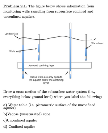
Transcribed Image Text:**Problem 9.1.** The figure below shows information from monitoring wells sampling from subsurface confined and unconfined aquifers.
**Diagram Description:**
- **Land Surface:** The top layer is labeled as the land surface, indicating where monitoring wells intersect the ground.
- **Wells:** Several vertical lines represent wells descending from the land surface into the subsurface layers. The water levels in these wells are marked, showing varying heights.
- **Water Level:** The water inside the wells demonstrates different levels, indicated by blue shading.
- **Aquitard, Confining Layer:** A horizontal band labeled as the aquitard or confining layer separates different water-bearing formations.
- **Notes on Wells:** A note on the diagram mentions that "these wells are only open to the aquifer below the confining layer."
**Task Instructions:**
Draw a cross-section of the subsurface water system (i.e., everything below ground level) and label the following:
a) **Water Table:** Identify the piezometric surface of the unconfined aquifer.
b) **Vadose (Unsaturated) Zone:** Label the unsaturated zone above the water table.
c) **Unconfined Aquifer:** Mark the aquifer that is directly open to the surface, not confined by an impermeable layer.
d) **Confined Aquifer:** Indicate the aquifer beneath the aquitard, which is under pressure due to confining layers above and below.

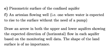
Transcribed Image Text:### Educational Text
**e) Piezometric surface of the confined aquifer**
**f) An artesian flowing well (i.e. one where water is expected to rise to the surface without the need of a pump)**
Draw an arrow in both the upper and lower aquifers showing the expected direction of (horizontal) flow in each aquifer based on the monitoring well data. The shape of the land surface is of no importance.
---
**Explanation of Concepts:**
- **Piezometric Surface**: This refers to the level to which water will naturally rise within a well in a confined aquifer due to the pressure in the aquifer.
- **Artesian Flowing Well**: This is a type of well where the pressure in the aquifer is sufficient to push water to the surface without artificial lifting.
In the context of this text, students or readers are expected to visualize or draw the direction of water flow based on data, which helps in understanding the natural movement of groundwater in aquifers.
Expert Solution
This question has been solved!
Explore an expertly crafted, step-by-step solution for a thorough understanding of key concepts.
This is a popular solution
Trending nowThis is a popular solution!
Step by stepSolved in 2 steps with 1 images

Knowledge Booster
Learn more about
Need a deep-dive on the concept behind this application? Look no further. Learn more about this topic, civil-engineering and related others by exploring similar questions and additional content below.Similar questions
- - once answered correctly will UPVOTE!!arrow_forwardCan you calculate the concentration at the end of the well using the 1-D steady advection-dispersion-reaction equation. The given parameters are distance = 200 m, Initial concentration = 10 mg/L, reaction = 0.0062 / day, dispersion = 1.5 m^2/d, and velocity = 0.5 m/d.arrow_forward
Recommended textbooks for you

 Structural Analysis (10th Edition)Civil EngineeringISBN:9780134610672Author:Russell C. HibbelerPublisher:PEARSON
 Principles of Foundation Engineering (MindTap Cou...Civil EngineeringISBN:9781337705028Author:Braja M. Das, Nagaratnam SivakuganPublisher:Cengage Learning
 Fundamentals of Structural AnalysisCivil EngineeringISBN:9780073398006Author:Kenneth M. Leet Emeritus, Chia-Ming Uang, Joel LanningPublisher:McGraw-Hill Education
 Traffic and Highway EngineeringCivil EngineeringISBN:9781305156241Author:Garber, Nicholas J.Publisher:Cengage Learning


Structural Analysis (10th Edition)
Civil Engineering
ISBN:9780134610672
Author:Russell C. Hibbeler
Publisher:PEARSON

Principles of Foundation Engineering (MindTap Cou...
Civil Engineering
ISBN:9781337705028
Author:Braja M. Das, Nagaratnam Sivakugan
Publisher:Cengage Learning

Fundamentals of Structural Analysis
Civil Engineering
ISBN:9780073398006
Author:Kenneth M. Leet Emeritus, Chia-Ming Uang, Joel Lanning
Publisher:McGraw-Hill Education


Traffic and Highway Engineering
Civil Engineering
ISBN:9781305156241
Author:Garber, Nicholas J.
Publisher:Cengage Learning