Applications and Investigations in Earth Science (9th Edition)
9th Edition
ISBN: 9780134746241
Author: Edward J. Tarbuck, Frederick K. Lutgens, Dennis G. Tasa
Publisher: PEARSON
expand_more
expand_more
format_list_bulleted
Question
Directions at top

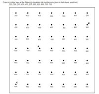
Transcribed Image Text:**Transcription of the Image**
**Instructions:**
Draw in contour lines at the following elevations (all numbers are given in feet above sea level):
250, 300, 350, 400, 450, 500, 550, 600, 650, 700, 750
**Elevation Grid:**
- **Row 1:**
350, 400, 400, 350, 350, 300, 250
- **Row 2:**
450, 500, 500, 450, 450, 400, 300
- **Row 3:**
550, 600, 600, 550, 500, 450, 350
- **Row 4:**
600, 650, 650, 600, 550, 500, 400
- **Row 5:**
650, 700, 700, 650, 600, 550, 450
- **Row 6:**
650, 750, 700, 650, 600, 550, 500
- **Row 7:**
600, 650, 650, 600, 550, 500, 450
**Points of Interest:**
- **Point A:** Located between 600 and 650 on the fourth row.
- **Point B:** Located between 300 and 400 on the second row.
- **Point C:** Located at 600 on the seventh row.
**Diagram Explanation:**
The diagram consists of a grid with numbers representing elevation points in feet above sea level. The task is to draw contour lines connecting points of similar elevation to illustrate topographic features. Points of interest (A, B, C) are marked to highlight specific locations within the grid for additional focus or identification during the contouring process.
Expert Solution
This question has been solved!
Explore an expertly crafted, step-by-step solution for a thorough understanding of key concepts.
This is a popular solution
Trending nowThis is a popular solution!
Step by stepSolved in 2 steps with 1 images

Knowledge Booster
Recommended textbooks for you
 Applications and Investigations in Earth Science ...Earth ScienceISBN:9780134746241Author:Edward J. Tarbuck, Frederick K. Lutgens, Dennis G. TasaPublisher:PEARSON
 Exercises for Weather & Climate (9th Edition)Earth ScienceISBN:9780134041360Author:Greg CarbonePublisher:PEARSON
 Environmental ScienceEarth ScienceISBN:9781260153125Author:William P Cunningham Prof., Mary Ann Cunningham ProfessorPublisher:McGraw-Hill Education
 Earth Science (15th Edition)Earth ScienceISBN:9780134543536Author:Edward J. Tarbuck, Frederick K. Lutgens, Dennis G. TasaPublisher:PEARSON
 Environmental Science (MindTap Course List)Earth ScienceISBN:9781337569613Author:G. Tyler Miller, Scott SpoolmanPublisher:Cengage Learning
 Physical GeologyEarth ScienceISBN:9781259916823Author:Plummer, Charles C., CARLSON, Diane H., Hammersley, LisaPublisher:Mcgraw-hill Education,

Applications and Investigations in Earth Science ...
Earth Science
ISBN:9780134746241
Author:Edward J. Tarbuck, Frederick K. Lutgens, Dennis G. Tasa
Publisher:PEARSON

Exercises for Weather & Climate (9th Edition)
Earth Science
ISBN:9780134041360
Author:Greg Carbone
Publisher:PEARSON

Environmental Science
Earth Science
ISBN:9781260153125
Author:William P Cunningham Prof., Mary Ann Cunningham Professor
Publisher:McGraw-Hill Education

Earth Science (15th Edition)
Earth Science
ISBN:9780134543536
Author:Edward J. Tarbuck, Frederick K. Lutgens, Dennis G. Tasa
Publisher:PEARSON

Environmental Science (MindTap Course List)
Earth Science
ISBN:9781337569613
Author:G. Tyler Miller, Scott Spoolman
Publisher:Cengage Learning

Physical Geology
Earth Science
ISBN:9781259916823
Author:Plummer, Charles C., CARLSON, Diane H., Hammersley, Lisa
Publisher:Mcgraw-hill Education,