
Applications and Investigations in Earth Science (9th Edition)
9th Edition
ISBN: 9780134746241
Author: Edward J. Tarbuck, Frederick K. Lutgens, Dennis G. Tasa
Publisher: PEARSON
expand_more
expand_more
format_list_bulleted
Related questions
Question
last 4 questions
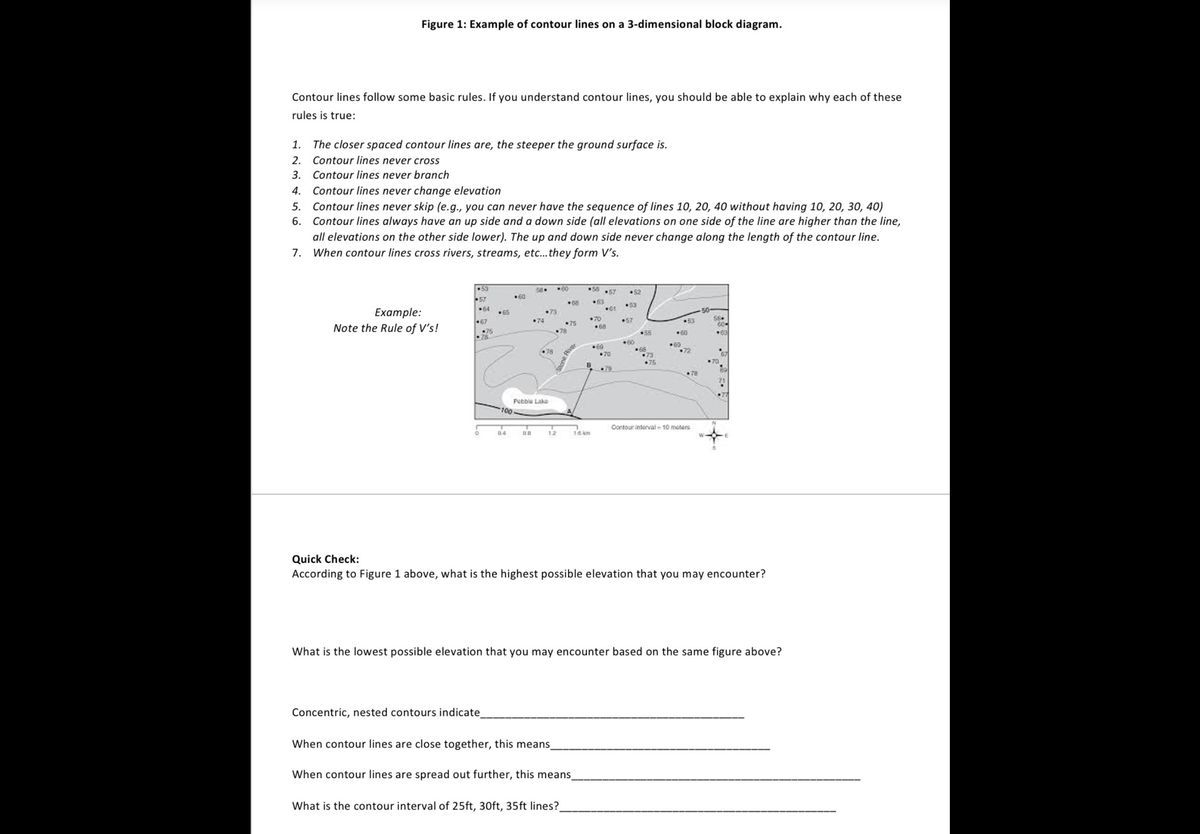

Transcribed Image Text:**Figure 1: Example of Contour Lines on a 3-Dimensional Block Diagram**
Contour lines follow some basic rules. If you understand contour lines, you should be able to explain why each of these rules is true:
1. The closer spaced contour lines are, the steeper the ground surface is.
2. Contour lines never cross.
3. Contour lines never branch.
4. Contour lines never change elevation.
5. Contour lines never skip (e.g., you can never have the sequence of lines 10, 20, 40 without having 10, 20, 30, 40).
6. Contour lines always have an up side and a down side (all elevations on one side of the line are higher than the line, all elevations on the other side lower). The up and down side never change along the length of the contour line.
7. When contour lines cross rivers, streams, etc., they form V's.
*Example: Note the Rule of V’s!*
Adjacent to the list of rules, there is a block diagram showing contour lines with various elevations such as +80, +70, +75, etc. This diagram demonstrates how contour lines form V-shapes when intersecting a river or stream.
**Quick Check:**
According to Figure 1 above, what is the highest possible elevation that you may encounter?
What is the lowest possible elevation that you may encounter based on the same figure above?
Concentric, nested contours indicate __________________________________________.
When contour lines are close together, this means _______________________________________.
When contour lines are spread out further, this means _______________________________________.
What is the contour interval of 25ft, 30ft, 35ft lines? _______________________________________.
Expert Solution
This question has been solved!
Explore an expertly crafted, step-by-step solution for a thorough understanding of key concepts.

This is a popular solution

Trending nowThis is a popular solution!

Step by stepSolved in 3 steps

Knowledge Booster

Recommended textbooks for you
- Applications and Investigations in Earth Science ...Earth ScienceISBN:9780134746241Author:Edward J. Tarbuck, Frederick K. Lutgens, Dennis G. TasaPublisher:PEARSON
 Exercises for Weather & Climate (9th Edition)Earth ScienceISBN:9780134041360Author:Greg CarbonePublisher:PEARSON
 Environmental ScienceEarth ScienceISBN:9781260153125Author:William P Cunningham Prof., Mary Ann Cunningham ProfessorPublisher:McGraw-Hill Education
  Earth Science (15th Edition)Earth ScienceISBN:9780134543536Author:Edward J. Tarbuck, Frederick K. Lutgens, Dennis G. TasaPublisher:PEARSON
 Environmental Science (MindTap Course List)Earth ScienceISBN:9781337569613Author:G. Tyler Miller, Scott SpoolmanPublisher:Cengage Learning
 Physical GeologyEarth ScienceISBN:9781259916823Author:Plummer, Charles C., CARLSON, Diane H., Hammersley, LisaPublisher:Mcgraw-hill Education,
Applications and Investigations in Earth Science ...
Earth Science
ISBN:9780134746241
Author:Edward J. Tarbuck, Frederick K. Lutgens, Dennis G. Tasa
Publisher:PEARSON
Exercises for Weather & Climate (9th Edition)
Earth Science
ISBN:9780134041360
Author:Greg Carbone
Publisher:PEARSON
Environmental Science
Earth Science
ISBN:9781260153125
Author:William P Cunningham Prof., Mary Ann Cunningham Professor
Publisher:McGraw-Hill Education
Earth Science (15th Edition)
Earth Science
ISBN:9780134543536
Author:Edward J. Tarbuck, Frederick K. Lutgens, Dennis G. Tasa
Publisher:PEARSON
Environmental Science (MindTap Course List)
Earth Science
ISBN:9781337569613
Author:G. Tyler Miller, Scott Spoolman
Publisher:Cengage Learning
Physical Geology
Earth Science
ISBN:9781259916823
Author:Plummer, Charles C., CARLSON, Diane H., Hammersley, Lisa
Publisher:Mcgraw-hill Education,