To draw:
The Earth’s grid system, including equator and prime meridian and also description of the system used to locate points on Earth’s surface.
Introduction:
The maps and globes display the system of east-west, and north-south lines, which is described as the Earth’s grid.
Explanation of Solution
Pictorial representation: Figure 1 represents the Earth’s grid system.
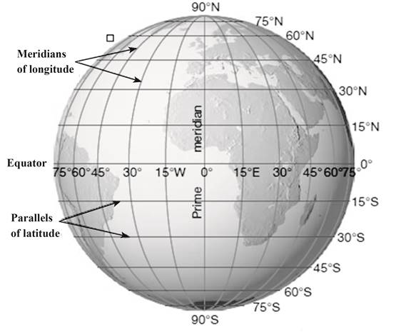
Fig. 1: Earth’s grid system
The north-south lines in figure 1 represent parallels of latitude, and the east-west lines represent meridians of longitude. The Earth’s grid system generates the basis for locating the points on the surface of Earth. The position of a specific point can be determined by the intersection of two lines. At prime meridian, the longitude is described as 0°. The location of a point is measured in degrees west and east of prime meridian from 0° to 180°.
Want to see more full solutions like this?
Chapter 22 Solutions
Applications and Investigations in Earth Science Plus Mastering Geology with eText -- Access Card Package (8th Edition)

 Applications and Investigations in Earth Science ...Earth ScienceISBN:9780134746241Author:Edward J. Tarbuck, Frederick K. Lutgens, Dennis G. TasaPublisher:PEARSON
 Exercises for Weather & Climate (9th Edition)Earth ScienceISBN:9780134041360Author:Greg CarbonePublisher:PEARSON
 Environmental ScienceEarth ScienceISBN:9781260153125Author:William P Cunningham Prof., Mary Ann Cunningham ProfessorPublisher:McGraw-Hill Education
 Earth Science (15th Edition)Earth ScienceISBN:9780134543536Author:Edward J. Tarbuck, Frederick K. Lutgens, Dennis G. TasaPublisher:PEARSON
 Environmental Science (MindTap Course List)Earth ScienceISBN:9781337569613Author:G. Tyler Miller, Scott SpoolmanPublisher:Cengage Learning
 Physical GeologyEarth ScienceISBN:9781259916823Author:Plummer, Charles C., CARLSON, Diane H., Hammersley, LisaPublisher:Mcgraw-hill Education,