Concept explainers
Please help me in answering the following soil
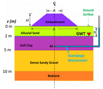
In the attached image, the cross-sectional soil profile of a road construction site can be seen. The plan is to construct a road embankment of height H = 3 meters, base width B = 10 meters, and top width A = 4 meters using a granular fill with a bulk density of 21 kN/m3. The embankment is symmetric about its vertical centreline.
Here, the soil profile consists of the following (attached in image as well):
- 2-meter-thick alluvial sand layer (GS = 2.65; e = 0.47; ϕ′ = 32◦)
- Overlying a 3-meter-thick normally consolidated soft clay layer (GS = 2.75; w = 36.5%; ϕ′ = 20◦ Cc = 0.30; Ce = 0.05; mv = 5.6 × 10⁻⁴ m2/kN; k = 1.2 × 10⁻¹⁰ m/s)
- Underlain by 5-meter-thick deposit of dense sandy gravel (γsat = 20 kN/m3; ϕ′ = 35◦)
- At 10 meters depth, Impermeable bedrock is encountered.
- Here, ground surface is horizontal and groundwater table (GWT) is initially hydrostatic located at a depth of 2 meter below the ground surface.
- The alluvial sand layer above the GWT is completely dry.
(a) If all the soil layers are under-at-rest earth pressure conditions, how can I calculate and plot the profiles of effective vertical stress σ'v and effective horizontal stress σ'h with depth z from the ground surface down to the top of the bedrock prior to the construction of the embankment?
(b) A standpipe manometer is installed at point M located within the soft clay layer at depth z = 4 meters from the ground surface and is allowed to come to hydrostatic equilibrium with the GWT before the construction of the embankment. If there is instantaneous embankment construction,what will be the height h of the water level inside the manometer with reference to the GWT before and immediately after the construction of the embankment?.

Step by stepSolved in 6 steps with 5 images

- Consider three layered soil strata as shown in the figure below. The total head loss for the given soil strata is: T 2 m Flow k₁ = 2 × 10-² cm/s D D 0.8 m 3 m k₂ = 3 × 102cm/s L=1m 2 m k₁ = 4 × 102cm/sarrow_forwardAn embankment for a highway 30 m wide and 1.5 m in compacted thickness is to be constructed from sandy soil trucked from a borrow pit. The water content of the sandy soil in a borrow pit is 15% and its void ratio is 0.69. The swell index is 1.2. The specification requires the embankment to be compacted to a dry unit weight of 18kN/m^3. Determine, for a 1-km length of embankment, the following;(d) Volume of the borrow pit material required considering swell. (e) The number of truckloads of sandy soil required for the construction. The full capacity of each truck is 22.2m3, and local government regulations require a maximum capacity of 90%. (f) The weight of dry soil in one truckload.arrow_forwardHerbaceous vegetation is used to protect and stabilize the slope. As shown in the figure, try to calculate the stability and safety factor FS=?It is known that c'=effective soil cohesion (t/m^2); θ=effective soil friction angle; ▲c'=effective soil cohesion due to root system increase (t/m^2); r1=soil above groundwater level Unit volume weight (t/m^3); r2 = unit volume weight of soil below the groundwater level (t/m^3); Ws = total weight of abcd soil above the potential sliding surface (t/m)arrow_forward
- A cut is made into a homogeneous soil as depicted in the figure below, at an angle of 60° with the horizontal. Calculate the resisting shear force in kN along the failure plane given that the shear force applied by the overlying soil wedge is 120 kN. The failure plane is at an angle of 40° from the horizontal direction and the ground water level is below this plane. Assume drained conditions for this question.arrow_forward8. Estimate the settlement of the center of the tank, shown in the sketch, due to consolidation of the 20-ft layer of clay. 80'diam. -Oil tank; 500 lb/sq ft 30' fine sand; 125 lb/cu ft 20'clay; qu = 1.3 tons/sq ft W = 54 % Wp = 26% W = 44% Isat = /15 lb /cu ft %3D Rock %3D %3Darrow_forwardGEO NO. 10 SOLVE AND SHOW THE COMPLETE SOLUTION.arrow_forward

 Structural Analysis (10th Edition)Civil EngineeringISBN:9780134610672Author:Russell C. HibbelerPublisher:PEARSON
 Principles of Foundation Engineering (MindTap Cou...Civil EngineeringISBN:9781337705028Author:Braja M. Das, Nagaratnam SivakuganPublisher:Cengage Learning
 Fundamentals of Structural AnalysisCivil EngineeringISBN:9780073398006Author:Kenneth M. Leet Emeritus, Chia-Ming Uang, Joel LanningPublisher:McGraw-Hill Education
 Traffic and Highway EngineeringCivil EngineeringISBN:9781305156241Author:Garber, Nicholas J.Publisher:Cengage Learning


