Applications and Investigations in Earth Science (9th Edition)
9th Edition
ISBN: 9780134746241
Author: Edward J. Tarbuck, Frederick K. Lutgens, Dennis G. Tasa
Publisher: PEARSON
expand_more
expand_more
format_list_bulleted
Question
Need help show full work

Transcribed Image Text:(Abando Wallace
Channe
2
Elkhorn Road
Parking Area
Linear Ridge
Beheaded
Channels
Offset
Channels
Page
CONTOUR INTERVAL S FEET
500 meters
1500 meters
2500 meters
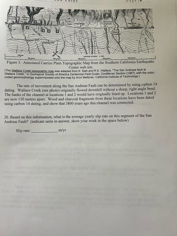
Figure 3. Annotated Carrizo Plain Topographic Map from the Southern California Earthquake
Center web site.
(The Wallace Creek topographic map was adapted from K. Sieh and R E. Wallace, "The San Andreas fault at
Wallace Creek," in Geological Society of America Centennial Field Guide, Cordilleran Section (1987), with the color-
coded geomorphology superimposed onto the map by Aron Meltzner, California Institute of Technology.)
The rate of movement along the San Andreas Fault can be determined by using carbon 14
dating. Wallace Creek (see photo) originally flowed downhill without a sharp, right angle bend.
The banks of the channel at locations 1 and 2 would have originally lined up. Locations 1 and 2
are now 130 meters apart. Wood and charcoal fragments from these locations have been dated
using carbon 14 dating, and show that 3800 years ago this channel was connected.
20. Based on this information, what is the average yearly slip rate on this segment of the San
Andreas Fault? (indicate units in answer, show your work in the space below)
Slip rate:
m/yr
Forcat are blincard
endaries t
Expert Solution
This question has been solved!
Explore an expertly crafted, step-by-step solution for a thorough understanding of key concepts.
This is a popular solution
Trending nowThis is a popular solution!
Step by stepSolved in 3 steps with 1 images

Knowledge Booster
Recommended textbooks for you
 Applications and Investigations in Earth Science ...Earth ScienceISBN:9780134746241Author:Edward J. Tarbuck, Frederick K. Lutgens, Dennis G. TasaPublisher:PEARSON
 Exercises for Weather & Climate (9th Edition)Earth ScienceISBN:9780134041360Author:Greg CarbonePublisher:PEARSON
 Environmental ScienceEarth ScienceISBN:9781260153125Author:William P Cunningham Prof., Mary Ann Cunningham ProfessorPublisher:McGraw-Hill Education
 Earth Science (15th Edition)Earth ScienceISBN:9780134543536Author:Edward J. Tarbuck, Frederick K. Lutgens, Dennis G. TasaPublisher:PEARSON
 Environmental Science (MindTap Course List)Earth ScienceISBN:9781337569613Author:G. Tyler Miller, Scott SpoolmanPublisher:Cengage Learning
 Physical GeologyEarth ScienceISBN:9781259916823Author:Plummer, Charles C., CARLSON, Diane H., Hammersley, LisaPublisher:Mcgraw-hill Education,

Applications and Investigations in Earth Science ...
Earth Science
ISBN:9780134746241
Author:Edward J. Tarbuck, Frederick K. Lutgens, Dennis G. Tasa
Publisher:PEARSON

Exercises for Weather & Climate (9th Edition)
Earth Science
ISBN:9780134041360
Author:Greg Carbone
Publisher:PEARSON

Environmental Science
Earth Science
ISBN:9781260153125
Author:William P Cunningham Prof., Mary Ann Cunningham Professor
Publisher:McGraw-Hill Education

Earth Science (15th Edition)
Earth Science
ISBN:9780134543536
Author:Edward J. Tarbuck, Frederick K. Lutgens, Dennis G. Tasa
Publisher:PEARSON

Environmental Science (MindTap Course List)
Earth Science
ISBN:9781337569613
Author:G. Tyler Miller, Scott Spoolman
Publisher:Cengage Learning

Physical Geology
Earth Science
ISBN:9781259916823
Author:Plummer, Charles C., CARLSON, Diane H., Hammersley, Lisa
Publisher:Mcgraw-hill Education,