Structural Analysis
6th Edition
ISBN: 9781337630931
Author: KASSIMALI, Aslam.
Publisher: Cengage,
expand_more
expand_more
format_list_bulleted
Concept explainers
Question

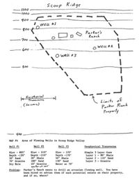
Transcribed Image Text:Scoop
Scoop Ridge
I100
1000
900
WEL #1
800-
Parker's
Ranch
700
O WELL *2 I
600
O WELL #3
500
kGorphysital
Transvarse
Limits of
Parker Raach
Property
(Sersmie)
400
MAP 4 Area of Floving Wells in Scoop Ridge Valley
Well 1
Well 12
Well 13
Ceophysical Transverne
Elev - 805
Depth -120'
50' Sand
70' Granite
Dry Hole
Elev - 610
Depth -210"
20 Shale
180' Sand
10' Granite
wa ter at 1of
Elev - 570
Depth -170
40' Shale
130' Sand
Water at 70'
Stmple 3 Layer Case
Layer 1- 80' Shale
Layer 2 - 110' Sand
Layer 3 - Granite
Problen: Parker's Ranch wants to drill an artesian floving vell. You have
been hired to advise them if such potential exists on their property,
and if so, vhere?
Expert Solution
This question has been solved!
Explore an expertly crafted, step-by-step solution for a thorough understanding of key concepts.
This is a popular solution
Trending nowThis is a popular solution!
Step by stepSolved in 2 steps

Knowledge Booster
Learn more about
Need a deep-dive on the concept behind this application? Look no further. Learn more about this topic, civil-engineering and related others by exploring similar questions and additional content below.Similar questions
- Construction Surveyingarrow_forwardThe results of a CPT test performed for a commercial site are presented in the image (You already classified the soil layer in homework #2). The layer soil type is shown by the legend and corresponding numbers in the figure. A strip footing with a size of 3x30 is built on the surface of the mentioned strata. A 300 kN/m load is acting on the footing. Use Schmertmann's method to compute the settlement of this footing 1 year after construction and 30 years after construction. Please show your calculation for at least one layer if you want use excel software for this problem. For easier calculation use E₂ = 39c- • • Neglect the foundation weight. • Assume the layers are in dry condition. Use unit weight as table below. Layer No. 1 2 3 4 5 6 7 Unit weght kN/m3 17 17 19 18 18.5 18 18arrow_forwardList unon au vu.. disau.. c) Describe embankment geometry with figure.arrow_forward
- N Rod ++ 50 1+50 1+75 2.6 Complete the set of differential leveling notes in Table 2-5, and perform the arithmetic 2.5 Prepare a set of profile leveling notes for the survey in Figure 2-34. In addition to comput- ing all elevations, show the arithmetic check and the resulting error in closure. check. 5.11 4.66 3.98 1.20 1.80 TP 2 4.42 4.30 2.01 Known Elevation is 402.78 4.72 TP 1 BM 61 Elevation = %3D 396.74 FIGURE 2-34 5-35 ()arrow_forwardGiven the following set of slope staking notes, find X2: Basis for Cut Basis for Fill Cutslope O 28.8 O 22.2 25.4 32.4 Sta. 5100 5000 4900 None of these. 52 38 s=2:1 ft ft L CX1 33.4 F 7.3 33.6 F 8.6 36.2 C C 5.5 FO F 3.5 R C 3.2 X2 C 4.1 34.2 FO 19arrow_forwardIt is desired to transport 20 cfs of water through a rectangular finishedconcrete (n = 0.012) canal that can be at most 5 ft wide. The slope of theland through which it passes is 0.0004. The depth of water, in ft, thatshould be expected is nearest: A. 1.83B. 1.28 (Incorrect Answer)C. 1.63 D. 1.01arrow_forward
arrow_back_ios
arrow_forward_ios
Recommended textbooks for you

 Structural Analysis (10th Edition)Civil EngineeringISBN:9780134610672Author:Russell C. HibbelerPublisher:PEARSON
 Principles of Foundation Engineering (MindTap Cou...Civil EngineeringISBN:9781337705028Author:Braja M. Das, Nagaratnam SivakuganPublisher:Cengage Learning
 Fundamentals of Structural AnalysisCivil EngineeringISBN:9780073398006Author:Kenneth M. Leet Emeritus, Chia-Ming Uang, Joel LanningPublisher:McGraw-Hill Education
 Traffic and Highway EngineeringCivil EngineeringISBN:9781305156241Author:Garber, Nicholas J.Publisher:Cengage Learning


Structural Analysis (10th Edition)
Civil Engineering
ISBN:9780134610672
Author:Russell C. Hibbeler
Publisher:PEARSON

Principles of Foundation Engineering (MindTap Cou...
Civil Engineering
ISBN:9781337705028
Author:Braja M. Das, Nagaratnam Sivakugan
Publisher:Cengage Learning

Fundamentals of Structural Analysis
Civil Engineering
ISBN:9780073398006
Author:Kenneth M. Leet Emeritus, Chia-Ming Uang, Joel Lanning
Publisher:McGraw-Hill Education


Traffic and Highway Engineering
Civil Engineering
ISBN:9781305156241
Author:Garber, Nicholas J.
Publisher:Cengage Learning