Structural Analysis
6th Edition
ISBN: 9781337630931
Author: KASSIMALI, Aslam.
Publisher: Cengage,
expand_more
expand_more
format_list_bulleted
Question
thumb_up100%
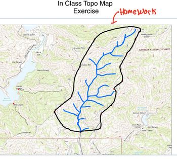
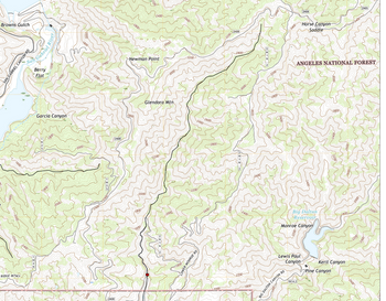
Please help me delineate the watershed given in the picture. The second picture it was me trying to do it but I don't know if it right. Thank you for your help!

Transcribed Image Text:1800-
2000
1600
-2200-
1400
Islip Canyon
Sharps
Cappo
Browns Gulch
SAN GABRIEL CANYON RD
San-Gabriel River
1600
Berry
Flat
Garcia Canyon
1800
Morris
Reservoir
Pine Canyon
2000
GLENDORA RIDGE MTWY
2200-
In Class Topo Map
Exercise
Homework
2400
2000-
2N08
2N08
Colby
1600
GLENDORA MOUNTAIN
Newman Point
2000
2400
3000
lendora Mtn
2000
1800
MONROE RD
2200
Mystic Canyon Trail
1800
16003
3200
2600
2200-
1800
3200N08
2N08
Horse Canyon
Saddle
2800
ANGELES NATIONAL FOREST
Big Dalton
Reservoir
Monroe Canyon
Lewis Paul
Canyon
BIG DALTON CANYON RD
1N14.3
Aviatic Convon
1800-
1N14.2
Big Cienegá
Spring
Keril Canyon
Pine Canyon
2800
2200
Johns
Pe

Transcribed Image Text:RIDGE MTWY
1800
Browns Gulch
SAN GABRIEL CANYON RD
San-Gabriel
2400-
1600
Berry
Flat
1200
Garcia Canyon
1800-
1800
2000
1800
2200
2800
2400
Newman Point
2000
2N08
2400
2400
2N08
2800
2000
2600.
2400
Glendora Mtn
2200
1800
2000
1600
3000
3000
2200
2400
2600
1800
LOWER MONROE RD
2000-
3200
2600
2400
2800-
2200-
1800
3200
2N08
2800-
3000
3200
2800
3400-
2N08
Horse Canyon
Saddle
3400
2N05
ANGELES NATIONAL FOREST
2800-
2400
Big Dalton
Reservoir
Monroe Canyon
1800
2000
Lewis Paul
Canyon
Keril Canyon
Pine Canyon
DALTON CANYON R
1N14.2
2600
Expert Solution
This question has been solved!
Explore an expertly crafted, step-by-step solution for a thorough understanding of key concepts.
Step by stepSolved in 2 steps

Knowledge Booster
Similar questions
Recommended textbooks for you

 Structural Analysis (10th Edition)Civil EngineeringISBN:9780134610672Author:Russell C. HibbelerPublisher:PEARSON
 Principles of Foundation Engineering (MindTap Cou...Civil EngineeringISBN:9781337705028Author:Braja M. Das, Nagaratnam SivakuganPublisher:Cengage Learning
 Fundamentals of Structural AnalysisCivil EngineeringISBN:9780073398006Author:Kenneth M. Leet Emeritus, Chia-Ming Uang, Joel LanningPublisher:McGraw-Hill Education
 Traffic and Highway EngineeringCivil EngineeringISBN:9781305156241Author:Garber, Nicholas J.Publisher:Cengage Learning


Structural Analysis (10th Edition)
Civil Engineering
ISBN:9780134610672
Author:Russell C. Hibbeler
Publisher:PEARSON

Principles of Foundation Engineering (MindTap Cou...
Civil Engineering
ISBN:9781337705028
Author:Braja M. Das, Nagaratnam Sivakugan
Publisher:Cengage Learning

Fundamentals of Structural Analysis
Civil Engineering
ISBN:9780073398006
Author:Kenneth M. Leet Emeritus, Chia-Ming Uang, Joel Lanning
Publisher:McGraw-Hill Education


Traffic and Highway Engineering
Civil Engineering
ISBN:9781305156241
Author:Garber, Nicholas J.
Publisher:Cengage Learning