Applications and Investigations in Earth Science (9th Edition)
9th Edition
ISBN: 9780134746241
Author: Edward J. Tarbuck, Frederick K. Lutgens, Dennis G. Tasa
Publisher: PEARSON
expand_more
expand_more
format_list_bulleted
Question
Help

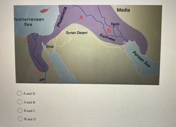
Transcribed Image Text:The map illustrates the region known as the Fertile Crescent, highlighting the areas of Mesopotamia. The Fertile Crescent is depicted in a shaded area that stretches from the Nile in Egypt, encompassing parts of the Levant, and reaching into the Tigris and Euphrates river valleys.
Key features on the map include:
- **Regions and Labels**:
- Assyria, Phoenicia, and Media are marked within the Fertile Crescent.
- The Syrian Desert is located to the south of Assyria.
- Anatolia is to the northwest of the map.
- **Water Bodies**:
- The Mediterranean Sea is to the west.
- The Persian Sea is situated to the southeast.
- The Tigris and Euphrates rivers flow through the Mesopotamian area, with the Euphrates labeled.
- **Letters Indicating Areas**:
- Letter A is located in the northeastern section of the shaded area, associated with Assyria.
- Letter B corresponds to the region between the Tigris and Euphrates rivers, indicative of Mesopotamia.
- Letter C is positioned towards the Mediterranean coast.
- Letter D is found near the Nile, at the western edge of the shaded Fertile Crescent, likely indicating Lower Egypt.
This map provides a geographical context for the historical and agricultural significance of the Fertile Crescent.

Transcribed Image Text:The image is a map highlighting the Fertile Crescent, a historically significant region known for early civilizations. It spans from the Mediterranean Sea to the Persian Gulf, covering parts of modern-day Middle East countries. The map is shaded to show specific areas and labeled with rivers and regions.
### Key Features:
- **Rivers:**
- **Tigris and Euphrates**: Marked in blue lines, flowing through area B.
- **Nile**: Extends through area C into area D.
- **Regions:**
- **Phoenicia**: Located near the Mediterranean Sea.
- **Media**: Positioned in the eastern part near the Persian Sea.
- **Syrian Desert**: Centered in the map.
- **Labels:**
- Areas are marked as A, B, C, and D.
- Area A is in the northeastern part near the Tigris.
- Area B is along the Euphrates.
- Area C is closer to the Mediterranean Sea.
- Area D extends along the Nile River.
### Multiple Choice Options:
- O A and D
- O A and B
- O B and C
- O B and D
The map highlights early civilization areas influenced by river systems, illustrating the significance of the Fertile Crescent in human history.
Expert Solution
This question has been solved!
Explore an expertly crafted, step-by-step solution for a thorough understanding of key concepts.
This is a popular solution
Trending nowThis is a popular solution!
Step by stepSolved in 3 steps

Knowledge Booster
Recommended textbooks for you
 Applications and Investigations in Earth Science ...Earth ScienceISBN:9780134746241Author:Edward J. Tarbuck, Frederick K. Lutgens, Dennis G. TasaPublisher:PEARSON
 Exercises for Weather & Climate (9th Edition)Earth ScienceISBN:9780134041360Author:Greg CarbonePublisher:PEARSON
 Environmental ScienceEarth ScienceISBN:9781260153125Author:William P Cunningham Prof., Mary Ann Cunningham ProfessorPublisher:McGraw-Hill Education
 Earth Science (15th Edition)Earth ScienceISBN:9780134543536Author:Edward J. Tarbuck, Frederick K. Lutgens, Dennis G. TasaPublisher:PEARSON
 Environmental Science (MindTap Course List)Earth ScienceISBN:9781337569613Author:G. Tyler Miller, Scott SpoolmanPublisher:Cengage Learning
 Physical GeologyEarth ScienceISBN:9781259916823Author:Plummer, Charles C., CARLSON, Diane H., Hammersley, LisaPublisher:Mcgraw-hill Education,

Applications and Investigations in Earth Science ...
Earth Science
ISBN:9780134746241
Author:Edward J. Tarbuck, Frederick K. Lutgens, Dennis G. Tasa
Publisher:PEARSON

Exercises for Weather & Climate (9th Edition)
Earth Science
ISBN:9780134041360
Author:Greg Carbone
Publisher:PEARSON

Environmental Science
Earth Science
ISBN:9781260153125
Author:William P Cunningham Prof., Mary Ann Cunningham Professor
Publisher:McGraw-Hill Education

Earth Science (15th Edition)
Earth Science
ISBN:9780134543536
Author:Edward J. Tarbuck, Frederick K. Lutgens, Dennis G. Tasa
Publisher:PEARSON

Environmental Science (MindTap Course List)
Earth Science
ISBN:9781337569613
Author:G. Tyler Miller, Scott Spoolman
Publisher:Cengage Learning

Physical Geology
Earth Science
ISBN:9781259916823
Author:Plummer, Charles C., CARLSON, Diane H., Hammersley, Lisa
Publisher:Mcgraw-hill Education,