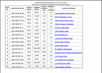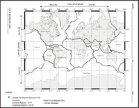
Hints for plotting: In order to PLOT an earthquake event, you will need to use the Latitude and Longitude information provided. Lines of Latitude appear horizontal (“side to side”) and are measured as degrees north (N) or south (S) of the equator (the equator is 0°). Longitude lines run vertically (“up and down”) and measure the degrees East (E) or West (W) of the Prime Meridian (0° runs through Greenwich, England). A sample plot of a theoretical Shallow depth earthquake at 60 deg W and 45 deg N has been plotted for you on the map. The Earthquake events that have been provided on the separate data sheet (from June 20 – July 18, 2021), can be assigned a ‘’depth code’’ according to the DEPTH (km) below the Earth’s surface that each one occurred. Using the following criteria:
Shallow depth earthquakes = 0-70 km Intermediate depth earthquakes = 70- 300 km Deep depth earthquakes = >(greater than) 300 km depth
QUESTION 11) Assign a ‘’Depth’’ code to Earthquake event 11 A) Shallow B) Intermediate C) Deep
QUESTION 12) Assign a ‘’Depth’’ code to Earthquake event 12 A) Shallow B) Intermediate C) Deep
QUESTION 13) Assign a ‘’Depth’’ code to Earthquake event 13 A) Shallow B) Intermediate C) Deep
QUESTION 14) Assign a ‘’Depth’’ code to Earthquake event 14 A) Shallow B) Intermediate C) Deep
QUESTION 15) Assign a ‘’Depth’’ code to Earthquake event 15 A) Shallow B) Intermediate C) Deep


Trending nowThis is a popular solution!
Step by stepSolved in 2 steps

 Applications and Investigations in Earth Science ...Earth ScienceISBN:9780134746241Author:Edward J. Tarbuck, Frederick K. Lutgens, Dennis G. TasaPublisher:PEARSON
 Exercises for Weather & Climate (9th Edition)Earth ScienceISBN:9780134041360Author:Greg CarbonePublisher:PEARSON
 Environmental ScienceEarth ScienceISBN:9781260153125Author:William P Cunningham Prof., Mary Ann Cunningham ProfessorPublisher:McGraw-Hill Education
 Earth Science (15th Edition)Earth ScienceISBN:9780134543536Author:Edward J. Tarbuck, Frederick K. Lutgens, Dennis G. TasaPublisher:PEARSON
 Environmental Science (MindTap Course List)Earth ScienceISBN:9781337569613Author:G. Tyler Miller, Scott SpoolmanPublisher:Cengage Learning
 Physical GeologyEarth ScienceISBN:9781259916823Author:Plummer, Charles C., CARLSON, Diane H., Hammersley, LisaPublisher:Mcgraw-hill Education,


