Structural Analysis
6th Edition
ISBN: 9781337630931
Author: KASSIMALI, Aslam.
Publisher: Cengage,
expand_more
expand_more
format_list_bulleted
Concept explainers
Question
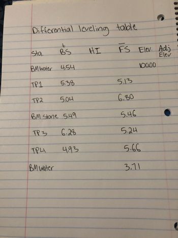
Fill out the differential leveling table with corresponding calculations (page check, misclosure, and adjustment).
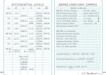
The first pic is an example

Transcribed Image Text:## Differential Levels
### Table Overview
This table summarizes the differential leveling data collected on a specific date. It includes information on the back sight (B.S.), height of the instrument (H.I.), fore sight (F.S.), elevation (Elev.), and adjusted elevation (Adj. Elev.) for various stations (Sta.). The detailed table below helps in determining elevation differences and ensuring accuracy in leveling across different points.
| Sta. | B.S. | H.I. | F.S. | Elev. | Adj. Elev. |
|-------|-------|----------|-------|----------|---------------------|
| BM Mil. | 1.33 | 2054.51 | | 2053.18 | 2053.18 |
| TP1 | 0.22 | | 8.37 | 2046.14 | 2046.14 (-0.004) |
| TP2 | 0.96 | 2046.36 | 7.91 | 2038.45 | 2038.44 (-0.008) |
| TP3 | 0.46 | 2039.41 | 11.72 | 2027.69 | 2027.68 (-0.012) |
| BM Oak | 11.95 | | 8.71 | 2019.44 | 2019.42 (-0.016) |
| TP4 | 12.55 | 2031.39 | 2.61 | 2028.78 | 2028.76 (-0.022) |
| TP5 | 12.77 | 2041.33 | 0.68 | 2040.65 | 2040.62 (-0.026) |
| BM Mil. | | 2053.42 | 0.21 | 2053.21 | 2053.18 (-0.030) |
### Page Check Calculation
This calculation ensures the accuracy of the recorded data:
\[
\text{Page Check:} \\
2053.18 \\
+ 40.24 \\
= 2093.42 \\
- 40.21 \\
= 2053

Transcribed Image Text:### Differential Leveling Table
Below is a transcription of a differential leveling table used for surveying elevations.
| Station | Back Sight (BS) | Height of Instrument (HI) | Fore Sight (FS) | Elevation (Elev.) | Adjusted Elevation (Adj. Elev.) |
|---------|-----------------|--------------------------|-----------------|-------------------|--------------------------------|
| BMwater | 4.54 | | | 100.00 | |
| TP1 | 5.38 | | 5.13 | | |
| TP2 | 5.04 | | 6.80 | | |
| BMstone | 5.49 | | 5.46 | | |
| TP3 | 6.28 | | 5.24 | | |
| TP4 | 4.93 | | 5.66 | | |
| BMwater | | | 3.71 | | |
**Explanation of Columns:**
1. **Station (Sta.):** The specific point where measurements are taken. Examples include benchmark water (BMwater), turning points (TP1, TP2, etc.), and benchmark stone (BMstone).
2. **Back Sight (BS):** A reading taken on a leveling rod held at a point of known or assumed elevation.
3. **Height of Instrument (HI):** The height of the leveling instrument above a chosen reference point.
4. **Fore Sight (FS):** A reading taken on a leveling rod held at an unknown point to determine its elevation.
5. **Elevation (Elev.):** The calculated or known elevation of the station point.
6. **Adjusted Elevation (Adj. Elev.):** Adjusted elevation values after calculations.
The table is used by surveyors to record and process elevations for accurate mapping and construction planning. Actual elevation values are recorded along with readings from the leveling instrument to calculate the desired values. In this table, some fields are not filled out, indicating stages of measurements or calculations that may be pending.
Expert Solution
This question has been solved!
Explore an expertly crafted, step-by-step solution for a thorough understanding of key concepts.
Step by stepSolved in 2 steps with 1 images

Knowledge Booster
Learn more about
Need a deep-dive on the concept behind this application? Look no further. Learn more about this topic, civil-engineering and related others by exploring similar questions and additional content below.Similar questions
- 3) The following table contains a set of measured levels for an open traverse Station CP1 (BM) 1a 1b CP2 2a 26 CP3 BS IS FS 1.430 3.370 2.010 1.010 2.980 1.410 0.400 0.670 RL 277.650 Find the RL values and do a checking i) use RISE and Fall Method ii) use Method of Height of Plane of Collimation<arrow_forwardDetermine the x and y coordinates of the centroid of the shaded area.arrow_forwardPLS SHOW COMPLETE ANSWER. THANK YOUarrow_forward
Recommended textbooks for you

 Structural Analysis (10th Edition)Civil EngineeringISBN:9780134610672Author:Russell C. HibbelerPublisher:PEARSON
 Principles of Foundation Engineering (MindTap Cou...Civil EngineeringISBN:9781337705028Author:Braja M. Das, Nagaratnam SivakuganPublisher:Cengage Learning
 Fundamentals of Structural AnalysisCivil EngineeringISBN:9780073398006Author:Kenneth M. Leet Emeritus, Chia-Ming Uang, Joel LanningPublisher:McGraw-Hill Education
 Traffic and Highway EngineeringCivil EngineeringISBN:9781305156241Author:Garber, Nicholas J.Publisher:Cengage Learning


Structural Analysis (10th Edition)
Civil Engineering
ISBN:9780134610672
Author:Russell C. Hibbeler
Publisher:PEARSON

Principles of Foundation Engineering (MindTap Cou...
Civil Engineering
ISBN:9781337705028
Author:Braja M. Das, Nagaratnam Sivakugan
Publisher:Cengage Learning

Fundamentals of Structural Analysis
Civil Engineering
ISBN:9780073398006
Author:Kenneth M. Leet Emeritus, Chia-Ming Uang, Joel Lanning
Publisher:McGraw-Hill Education


Traffic and Highway Engineering
Civil Engineering
ISBN:9781305156241
Author:Garber, Nicholas J.
Publisher:Cengage Learning