Question
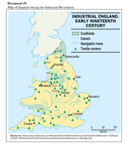
Explain a turning point associated with the events or ideas in documents 1 and 2. Be sure to use evidence from both documents 1 and 2 in your response.
![Document #2
Robert J. Southey was a British writer who was born during the Industrial Revolution.
“..A place more destitute of all interesting objects than Manchester, it is not easy to conceive. In size and population it
is the second city in the kingdom, containing above fourscore thousand [80,000] inhabitants. Imagine this multitude
crowded together in narrow streets, the houses all built of brick and blackened with smoke; frequent buildings among
them as large as convents, without their antiquity, without their beauty, without their holiness; where you hear from within,
as you pass along, the everlasting din of machinery; and where when the bell rings it is to call wretches to their work
instead of their prayers, ..."
- Robert J. Southey, Letters from England, 1807](https://content.bartleby.com/qna-images/question/6c291a90-ac86-4575-9ac1-7e442070fc9d/e6700825-f315-408c-a04a-e48c604d7892/45g25nwp_thumbnail.png)
Transcribed Image Text:Document #2
Robert J. Southey was a British writer who was born during the Industrial Revolution.
“..A place more destitute of all interesting objects than Manchester, it is not easy to conceive. In size and population it
is the second city in the kingdom, containing above fourscore thousand [80,000] inhabitants. Imagine this multitude
crowded together in narrow streets, the houses all built of brick and blackened with smoke; frequent buildings among
them as large as convents, without their antiquity, without their beauty, without their holiness; where you hear from within,
as you pass along, the everlasting din of machinery; and where when the bell rings it is to call wretches to their work
instead of their prayers, ..."
- Robert J. Southey, Letters from England, 1807

Transcribed Image Text:Document #1
Map of England during the Industrial Revolution.
INDUSTRIAL ENGLAND,
EARLY NINETEENTH
CENTURY
Coalfields
Canals
Navigable rivers
Textile centers
lead
ZincA* Newcastle
Mron
„Kendal
Hull
Lead
Nantwich Zinc
lead
Ashby
Norwich
Iron
London
Exeter
50
100
MILES
Sourcehttp://historymaps.wikispaces.com/file/viewiEarty%2019th20Century%20lndustrial%20Revolution-%20Engla
nd.gif/471687920/Early%2019th%20Century20lndustria.20Revolution-N20England.gif
Expert Solution
This question has been solved!
Explore an expertly crafted, step-by-step solution for a thorough understanding of key concepts.
This is a popular solution
Trending nowThis is a popular solution!
Step by stepSolved in 3 steps
