Applications and Investigations in Earth Science (9th Edition)
9th Edition
ISBN: 9780134746241
Author: Edward J. Tarbuck, Frederick K. Lutgens, Dennis G. Tasa
Publisher: PEARSON
expand_more
expand_more
format_list_bulleted
Question

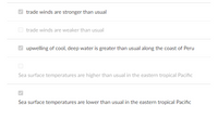
Transcribed Image Text:### Climate Dynamics: Understanding Ocean Atmospheric Interactions
**Caption: Key indicators of Ocean and Atmospheric Conditions**
This section highlights critical indicators of oceanic and atmospheric conditions that influence global weather patterns, especially related to phenomena such as El Niño and La Niña.
#### Important Indicators:
1. **Trade Winds:**
- **Trade winds are stronger than usual:**
When trade winds are stronger, they push warmer surface water westward, enhancing upwelling of cooler, nutrient-rich water along the eastern Pacific.
- Trade winds are weaker than usual:
Weaker trade winds diminish this westward push, typically leading to a reduction in the upwelling of cool water along the eastern Pacific coast.
2. **Upwelling Conditions:**
- **Upwelling of cool, deep water is greater than usual along the coast of Peru:**
Enhanced upwelling is associated with stronger trade winds, bringing nutrient-rich cold water to the surface, which can significantly impact marine life and local climate conditions.
3. **Sea Surface Temperatures:**
- Sea surface temperatures are higher than usual in the eastern tropical Pacific:
Elevated sea surface temperatures often signal the onset of El Niño, impacting weather patterns globally.
- **Sea surface temperatures are lower than usual in the eastern tropical Pacific:**
Lower sea surface temperatures generally indicate La Niña conditions, influencing global climate patterns differently from El Niño.
**Understanding these indicators is crucial for predicting climate phenomena and preparing for their diverse impacts worldwide.**

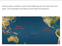
Transcribed Image Text:**Understanding La Niña Conditions:**
**Question:**
During La Niña conditions, which of the following are true? Select ALL that apply. (The map below may help you think about the question.)
**Explanation:**
**Map Description:**
- The map provided shows the equatorial region of the Pacific Ocean, highlighting important geographical areas relevant to La Niña conditions.
- The Equator is marked with a dashed red line extending horizontally across the middle of the map.
- Key regions on the map are labeled:
- Western Pacific Ocean
- Eastern Pacific Ocean
- Indonesia
- The map displays parts of surrounding continents, including Southeast Asia on the left side and the western coast of the Americas on the right side.
**La Niña Overview:**
- La Niña is a climate pattern characterized by cooler-than-average sea surface temperatures in the central and eastern tropical Pacific Ocean.
- This phenomenon often impacts global weather patterns, causing changes in precipitation, temperature, and storm activity.
**Question Context:**
Consider the map and the information on La Niña to determine which statements about La Niña are accurate.
Expert Solution
This question has been solved!
Explore an expertly crafted, step-by-step solution for a thorough understanding of key concepts.
This is a popular solution
Trending nowThis is a popular solution!
Step by stepSolved in 2 steps

Knowledge Booster
Recommended textbooks for you
 Applications and Investigations in Earth Science ...Earth ScienceISBN:9780134746241Author:Edward J. Tarbuck, Frederick K. Lutgens, Dennis G. TasaPublisher:PEARSON
 Exercises for Weather & Climate (9th Edition)Earth ScienceISBN:9780134041360Author:Greg CarbonePublisher:PEARSON
 Environmental ScienceEarth ScienceISBN:9781260153125Author:William P Cunningham Prof., Mary Ann Cunningham ProfessorPublisher:McGraw-Hill Education
 Earth Science (15th Edition)Earth ScienceISBN:9780134543536Author:Edward J. Tarbuck, Frederick K. Lutgens, Dennis G. TasaPublisher:PEARSON
 Environmental Science (MindTap Course List)Earth ScienceISBN:9781337569613Author:G. Tyler Miller, Scott SpoolmanPublisher:Cengage Learning
 Physical GeologyEarth ScienceISBN:9781259916823Author:Plummer, Charles C., CARLSON, Diane H., Hammersley, LisaPublisher:Mcgraw-hill Education,

Applications and Investigations in Earth Science ...
Earth Science
ISBN:9780134746241
Author:Edward J. Tarbuck, Frederick K. Lutgens, Dennis G. Tasa
Publisher:PEARSON

Exercises for Weather & Climate (9th Edition)
Earth Science
ISBN:9780134041360
Author:Greg Carbone
Publisher:PEARSON

Environmental Science
Earth Science
ISBN:9781260153125
Author:William P Cunningham Prof., Mary Ann Cunningham Professor
Publisher:McGraw-Hill Education

Earth Science (15th Edition)
Earth Science
ISBN:9780134543536
Author:Edward J. Tarbuck, Frederick K. Lutgens, Dennis G. Tasa
Publisher:PEARSON

Environmental Science (MindTap Course List)
Earth Science
ISBN:9781337569613
Author:G. Tyler Miller, Scott Spoolman
Publisher:Cengage Learning

Physical Geology
Earth Science
ISBN:9781259916823
Author:Plummer, Charles C., CARLSON, Diane H., Hammersley, Lisa
Publisher:Mcgraw-hill Education,