Related questions
Question

Transcribed Image Text:Details
Basemap
i About
Content
Legend
+
Contents
World Imagery
USA Topo Maps
5200
4800-
WHson
Esri.com Help Terms of Use Privacy Contact Esri. Report Abuse
2mt
5400
Ridg
5600
Print▾
Halal Measure
Mount Mitchell, NC, USA
STATE
BLACK
Ridge 6200
TCHELL
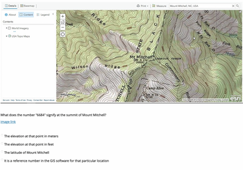
Mt Mitchell
(BM N 16)
(6684)
6400
LOOKOUT TOWER
Commissary
Camp Alice
BM N 15
5789
6000
What does the number "6684" signify at the summit of Mount Mitchell?
image link
The elevation at that point in meters
The elevation at that point in feet
The latitude of Mount Mitchell
It is a reference number in the GIS software for that particular location
5800
xQ
Fk Rock Cr
Fark
Ridge
North
Rid
Fork
Rock
Middle
5600
POWERED BY
Copyright: ©2013 National Geographic Society, i-cubed
esri
Expert Solution
This question has been solved!
Explore an expertly crafted, step-by-step solution for a thorough understanding of key concepts.
Step by stepSolved in 2 steps
