
Applications and Investigations in Earth Science (9th Edition)
9th Edition
ISBN: 9780134746241
Author: Edward J. Tarbuck, Frederick K. Lutgens, Dennis G. Tasa
Publisher: PEARSON
expand_more
expand_more
format_list_bulleted
Related questions
Question
thumb_up100%
Thank you in advance!!
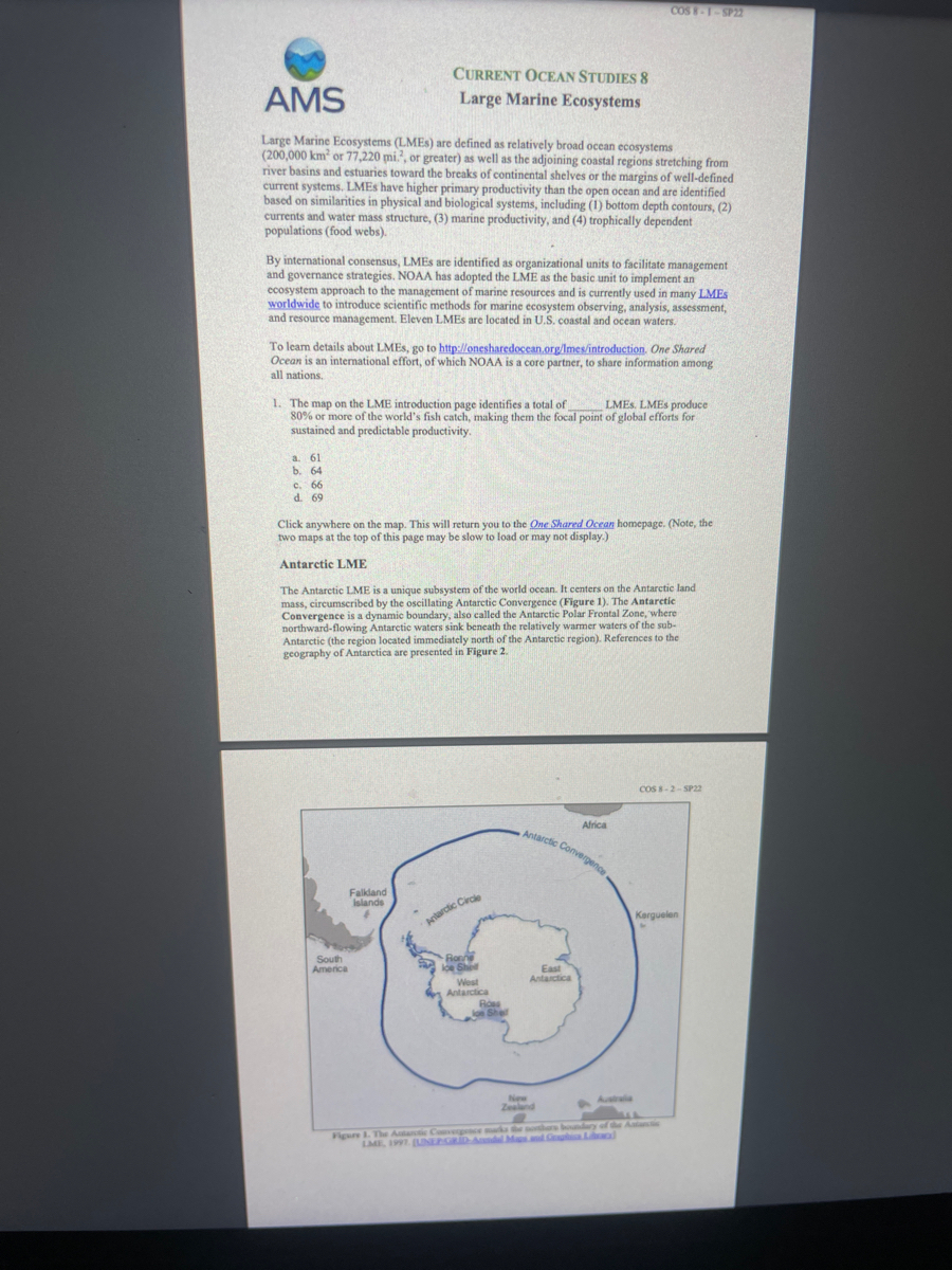

Transcribed Image Text:AMS
Large Marine Ecosystems (LMEs) are defined as relatively broad ocean ecosystems
(200,000 km² or 77,220 mi?, or greater) as well as the adjoining coastal regions stretching from
river basins and estuaries toward the breaks of continental shelves or the margins of well-defined
current systems. LMEs have higher primary productivity than the open ocean and are identified
based on similarities in physical and biological systems, including (1) bottom depth contours, (2)
currents and water mass structure, (3) marine productivity, and (4) trophically dependent
populations (food webs).
By international consensus, LMEs are identified as organizational units to facilitate management
and governance strategies. NOAA has adopted the LME as the basic unit to implement an
ecosystem approach to the management of marine resources and is currently used in many LMES
worldwide to introduce scientific methods for marine ecosystem observing, analysis, assessment,
and resource management. Eleven LMEs are located in U.S. coastal and ocean waters.
CURRENT OCEAN STUDIES 8
Large Marine Ecosystems
To learn details about LMEs, go to http://onesharedocean.org/Imes/introduction. One Shared
Ocean is an international effort, of which NOAA is a core partner, to share information among
all nations.
a. 61
b. 64
1. The map on the LME introduction page identifies a total of LMES. LMEs produce
80% or more of the world's fish catch, making them the focal point of global efforts for
sustained and predictable productivity.
c. 66
d. 69
South
America
Click anywhere on the map. This will return you to the One Shared Ocean homepage. (Note, the
two maps at the top of this page may be slow to load or may not display.)
Antarctic LME
The Antarctic LME is a unique subsystem of the world ocean. It centers on the Antarctic land
mass, circumscribed by the oscillating Antarctic Convergence (Figure 1). The Antarctic
Convergence is a dynamic boundary, also called the Antarctic Polar Frontal Zone, where i
northward-flowing Antarctic waters sink beneath the relatively warmer waters of the sub-
Antarctic (the region located immediately north of the Antarctic region). References to the
geography of Antarctica are presented in Figure 2.
Falkland
Islands
Antarctic Circle
Ronne
loe Shed
West
Antarctica
COS 8-1-SP22
Ros
on Shef
Antarctic Convergence-
Africa
East
Antarctica
COS 8-2-SP22
Kerguelen
New
Zealand
Figure 1. The Atlantic Convergence marks the northers boundary of the Atlantis

Transcribed Image Text:SOUTH
AMERICA
M
South Atlantic Ocean
Sea
Scotia
Sea
Bellingshausen
era
Amundsen
Sea
South Pacific Ocean
Wedd
Sea
January to February
b. August to September
c. October to November
Southern Ocean
Dronning Maud
a very low
b. low
c. medium
& high
e. very high
he EAST ANTARCTICA
WEST
ANTARCTICA
Rows
Shaf
Ross Sea
a. Weddell Sea
4
b. Southern Ocean
c. Pacific, Indian, and Atlantic Oceans
Southern Ocean
(AFRICA)
Enderly
d
(AUSTRALIA)
Figure 2. Geographic references for Antarctica. [NSIDCUniversity of Colorado
Boulder)
Davis
Se
2. From the One Share Ocean homepage, click on "Click here to choose an LME" at the upper
right and select "61 Antarctica." Scroll down and click on "Productivity." The graph shows
that the maximum chlorophyll-a concentration over the period of a year occurs from
(Scroll over the graph to see monthly data.)
Indian
Ocean
The presence of chlorophyll-a indicates the rate of organic matter synthesized from inorganic
substances. The greater the concentration, the greater the production of biomass. Consequently, it
can be assumed that the maximum productivity takes place during the Southern Hemisphere
summer
3. The Antarctic Convergence (Figure 1) separates the cold and slightly lower-salinity ocean
water surrounding the Antarctica land mass from relatively warmer and higher-salinity water
at lower latitudes. Found between about 48°S and 60'S, its location approximates the
southern boundary(ies) of the The exact position varies seasonally, affected by
winds, currents, and ocean conditions.
COS 8-4-SP22
The Antarctic Convergence marks an important climate boundary between both water masses
and air masses. Characterized by extreme weather conditions and the impacts of Antarctica's
freshwater ice cap, the Antarctic LME is like none other on Earth, especially the ecological and
biological characteristics of Antarctic species. The food chain is very short and almost entirely
based on shrimp-like crustaceans called krill. Baleen whales, seals, penguins, squid, fish, and
seabirds all feed on krill.
Marine species evolved to live in an ocean with a relatively narrow range of chemical and
physical characteristics. Changes in ocean chemistry have disrupted the function of ecosystems
and the normal interactions among species and, in some cases, exceed the tolerable limits of
certain organisms. Unless those organisms are mobile and able to migrate to a more favorable
environment, they likely will perish. Particularly interesting are changes in ocean chemistry that
are linked to changes in the global carbon cycle and climate.
Gulf of Mexico LME
Return to One Shared Ocean, click on "Click here to choose an LME" and select "05 Gulf of
Mexico. Scroll down and click on "Pollution." Read about the Nutrient ratio, Nitrogen load and
Merged Indicator, as well as the following information about nitrogen and nutrients
4. The risk level in the Gulf of Mexico for outrient ratio, nitrogen load, and merged nutrients is
mostly
When excess nutrients, especially nitrogen and phosphorus compounds, enter coastal surface
waters they spur algal blooms. Algal blooms metabolize much of the oxygen in the water and, as
they die off, they sink to the floor and their mass decomposition further depletes the oxygen
creating a dead zone in bottom or near-bottom waters with fatally low concentrations of oxygen.
This creates a hypoxic (low oxygen) or anasic (no oxygen) environment. There are now
estimated to be over 400 dead zones worldwide, mostly seasonal.
Expert Solution
This question has been solved!
Explore an expertly crafted, step-by-step solution for a thorough understanding of key concepts.

This is a popular solution

Trending nowThis is a popular solution!

Step by stepSolved in 2 steps

Knowledge Booster

Recommended textbooks for you
- Applications and Investigations in Earth Science ...Earth ScienceISBN:9780134746241Author:Edward J. Tarbuck, Frederick K. Lutgens, Dennis G. TasaPublisher:PEARSON
 Exercises for Weather & Climate (9th Edition)Earth ScienceISBN:9780134041360Author:Greg CarbonePublisher:PEARSON
 Environmental ScienceEarth ScienceISBN:9781260153125Author:William P Cunningham Prof., Mary Ann Cunningham ProfessorPublisher:McGraw-Hill Education
  Earth Science (15th Edition)Earth ScienceISBN:9780134543536Author:Edward J. Tarbuck, Frederick K. Lutgens, Dennis G. TasaPublisher:PEARSON
 Environmental Science (MindTap Course List)Earth ScienceISBN:9781337569613Author:G. Tyler Miller, Scott SpoolmanPublisher:Cengage Learning
 Physical GeologyEarth ScienceISBN:9781259916823Author:Plummer, Charles C., CARLSON, Diane H., Hammersley, LisaPublisher:Mcgraw-hill Education,
Applications and Investigations in Earth Science ...
Earth Science
ISBN:9780134746241
Author:Edward J. Tarbuck, Frederick K. Lutgens, Dennis G. Tasa
Publisher:PEARSON
Exercises for Weather & Climate (9th Edition)
Earth Science
ISBN:9780134041360
Author:Greg Carbone
Publisher:PEARSON
Environmental Science
Earth Science
ISBN:9781260153125
Author:William P Cunningham Prof., Mary Ann Cunningham Professor
Publisher:McGraw-Hill Education
Earth Science (15th Edition)
Earth Science
ISBN:9780134543536
Author:Edward J. Tarbuck, Frederick K. Lutgens, Dennis G. Tasa
Publisher:PEARSON
Environmental Science (MindTap Course List)
Earth Science
ISBN:9781337569613
Author:G. Tyler Miller, Scott Spoolman
Publisher:Cengage Learning
Physical Geology
Earth Science
ISBN:9781259916823
Author:Plummer, Charles C., CARLSON, Diane H., Hammersley, Lisa
Publisher:Mcgraw-hill Education,