Advanced Engineering Mathematics
10th Edition
ISBN: 9780470458365
Author: Erwin Kreyszig
Publisher: Wiley, John & Sons, Incorporated
expand_more
expand_more
format_list_bulleted
Question
not use ai please don't
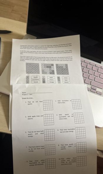
Transcribed Image Text:A geographic information system is a system for organizing, analyzing, and drawing conclusions
from geographic data. A raster map gives an area of land that is then divided into squares. Data
about each square is then attached to the squares.
In the first raster map below, the type of mineral available in each square is given. These raster
maps can be combined to make a new raster map that gives information about multiple pieces of
data
Terry has a square plot of land measuring 500 meters by 500 meters. She divided the land into 25
100-m by 100-m plots and created three raster maps showing the type of mineral, fruit tree, and
energy available on each plot. Use the maps below to shade the blank maps according to each
problem.
T
Qat
TQQQ a
T TOGG
T T TG G
G
G
A CCCO
A COOA
AACA
WEEE W
wwwEW
55www
C
AAC
0
SSWSS
C
A °
SS WS
5.
a
Quartz
A
Apple
T
Tourmaline
C
Cherry
W
S
Wind
Solar
G
Garnet
о
Orange
Electric
CCC
LLLL
COLL
E
Name
Project 1-Sets
Shade the areas...
1. That do not have
quartz.
3. With apple trees and
electric.
2. With tourmaline or
cherry trees.
4. With
quartz
tourmaline, but not
cherry trees.
5. That do not have both
and
quartz
energy.
wind
6. That have tourmaline
but not solar energy.
7. That have cherry trees
or do not have wind
energy.
8. That have quartz or
orange trees
electric.
or
9. That
have
tourmaline
either
or solar
10. That
either have
quartz and
orange
energy, but not both.
trees or tourmaline
and cherry trees.
Expert Solution
This question has been solved!
Explore an expertly crafted, step-by-step solution for a thorough understanding of key concepts.
Step by stepSolved in 2 steps with 10 images

Knowledge Booster
Similar questions
Recommended textbooks for you
 Advanced Engineering MathematicsAdvanced MathISBN:9780470458365Author:Erwin KreyszigPublisher:Wiley, John & Sons, Incorporated
 Numerical Methods for EngineersAdvanced MathISBN:9780073397924Author:Steven C. Chapra Dr., Raymond P. CanalePublisher:McGraw-Hill Education
 Introductory Mathematics for Engineering Applicat...Advanced MathISBN:9781118141809Author:Nathan KlingbeilPublisher:WILEY
 Mathematics For Machine TechnologyAdvanced MathISBN:9781337798310Author:Peterson, John.Publisher:Cengage Learning,

Advanced Engineering Mathematics
Advanced Math
ISBN:9780470458365
Author:Erwin Kreyszig
Publisher:Wiley, John & Sons, Incorporated

Numerical Methods for Engineers
Advanced Math
ISBN:9780073397924
Author:Steven C. Chapra Dr., Raymond P. Canale
Publisher:McGraw-Hill Education

Introductory Mathematics for Engineering Applicat...
Advanced Math
ISBN:9781118141809
Author:Nathan Klingbeil
Publisher:WILEY

Mathematics For Machine Technology
Advanced Math
ISBN:9781337798310
Author:Peterson, John.
Publisher:Cengage Learning,

