
Applications and Investigations in Earth Science (9th Edition)
9th Edition
ISBN: 9780134746241
Author: Edward J. Tarbuck, Frederick K. Lutgens, Dennis G. Tasa
Publisher: PEARSON
expand_more
expand_more
format_list_bulleted
Related questions
Question

Transcribed Image Text:9. Location #2 - Deming, WA: Deming, WA, represents the middle section of the Nooksack
River. Use Google Earth to observe the river in this location and answer the following
questions.
9a. Describe the setting for this river. (What would it look like if you were standing there?)
9b. Describe the river channel itself, including its width, apparent water depth, shape of the
path it is taking, and the apparent size of the material that makes up the river bed.
9c. Use the Ruler tool to calculate the gradient of the river at this location. Report the
upstream elevation, downstream elevation, horizontal distance, and river gradient.
Note that the river has several bends (called meanders) in it and several sandbars (the
tan-colored areas along the river). Use the Historical Imagery tool (the clock button) to view
aerial photos of the river for November 2011, July 2007, and July 1998. For each time period,
use the Add Path tool (the connect-the-dots button) to trace the location of the main river
channel. Then answer the following questions based on the locations of the meanders and
sandbars over time.
appear to be eroding over time. Describe thes
9e. Note the parts of the river that appear to be depositing new sediment over time.
Describe these location(s).
9d. Note the parts of the river
location(s).
9f. Look up and down the river using the current image. Does the riverbed remain in one
location or does it move? What evidence supports your conclusion?
9g. Predict what the river will look like in five years and explain why this will happen.
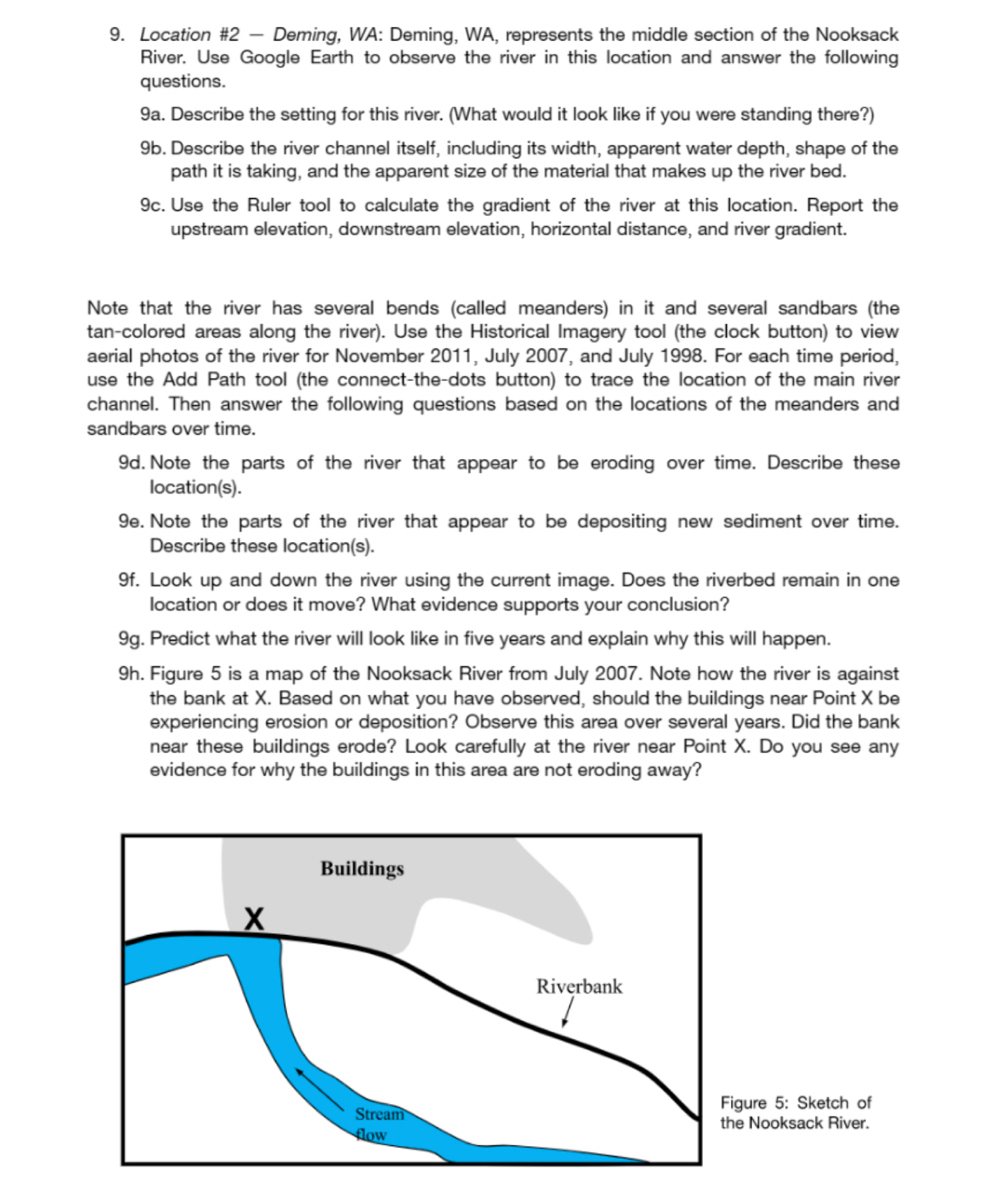
9h. Figure 5 is a map of the Nooksack River from July 2007. Note how the river is against
the bank at X. Based on what you have observed, should the buildings near Point X be
experiencing erosion or deposition? Observe this area over several years. Did the bank
near these buildings erode? Look carefully at the river near Point X. Do you see any
evidence for why the buildings in this area are not eroding away?
X
Buildings
Stream
flow
Riverbank
Figure 5: Sketch of
the Nooksack River.
Expert Solution
This question has been solved!
Explore an expertly crafted, step-by-step solution for a thorough understanding of key concepts.

This is a popular solution

Trending nowThis is a popular solution!

Step by stepSolved in 4 steps

Knowledge Booster

Recommended textbooks for you
- Applications and Investigations in Earth Science ...Earth ScienceISBN:9780134746241Author:Edward J. Tarbuck, Frederick K. Lutgens, Dennis G. TasaPublisher:PEARSON
 Exercises for Weather & Climate (9th Edition)Earth ScienceISBN:9780134041360Author:Greg CarbonePublisher:PEARSON
 Environmental ScienceEarth ScienceISBN:9781260153125Author:William P Cunningham Prof., Mary Ann Cunningham ProfessorPublisher:McGraw-Hill Education
  Earth Science (15th Edition)Earth ScienceISBN:9780134543536Author:Edward J. Tarbuck, Frederick K. Lutgens, Dennis G. TasaPublisher:PEARSON
 Environmental Science (MindTap Course List)Earth ScienceISBN:9781337569613Author:G. Tyler Miller, Scott SpoolmanPublisher:Cengage Learning
 Physical GeologyEarth ScienceISBN:9781259916823Author:Plummer, Charles C., CARLSON, Diane H., Hammersley, LisaPublisher:Mcgraw-hill Education,
Applications and Investigations in Earth Science ...
Earth Science
ISBN:9780134746241
Author:Edward J. Tarbuck, Frederick K. Lutgens, Dennis G. Tasa
Publisher:PEARSON
Exercises for Weather & Climate (9th Edition)
Earth Science
ISBN:9780134041360
Author:Greg Carbone
Publisher:PEARSON
Environmental Science
Earth Science
ISBN:9781260153125
Author:William P Cunningham Prof., Mary Ann Cunningham Professor
Publisher:McGraw-Hill Education
Earth Science (15th Edition)
Earth Science
ISBN:9780134543536
Author:Edward J. Tarbuck, Frederick K. Lutgens, Dennis G. Tasa
Publisher:PEARSON
Environmental Science (MindTap Course List)
Earth Science
ISBN:9781337569613
Author:G. Tyler Miller, Scott Spoolman
Publisher:Cengage Learning
Physical Geology
Earth Science
ISBN:9781259916823
Author:Plummer, Charles C., CARLSON, Diane H., Hammersley, Lisa
Publisher:Mcgraw-hill Education,