
Applications and Investigations in Earth Science (9th Edition)
9th Edition
ISBN: 9780134746241
Author: Edward J. Tarbuck, Frederick K. Lutgens, Dennis G. Tasa
Publisher: PEARSON
expand_more
expand_more
format_list_bulleted
Related questions
Question
27

Transcribed Image Text:Esc
F2
F3
**+
PrtSc
F4
FS
FO
*F12
FT
F9
F10
F11
Insert
@
23
%
&
*
Pale
8
IM 790
B
Prairie
SeuppeknOng
Pumping
Satiens
16
Uyper
Spring Lake
(u)
H013reval
A
L
M
E
Cem
ilmyta Aa
RJA
Se
pesPalmyra
VBM 848)
24
19 Spring
T5 N
20
lea 21
Spring Lake
Corner Grove Sch
A
29
KETTLE
MORAINE
TATE
FORLST
Blue/Spring
Lake
Battle Creek
PACI
BN 86
36
A
PAUL
Baopononk
Mees/ Cem
INE
TRANSMISSION
Flowng
Well
eFish Hatchery
WALWORTH Jeo
MILWAUKEE
BM 956
Little Prairie
-Cem-
20
12
BM
966
8.
T4N
-840
Lake
La Grange
ZBM 955
687
1944
Gravel Pit
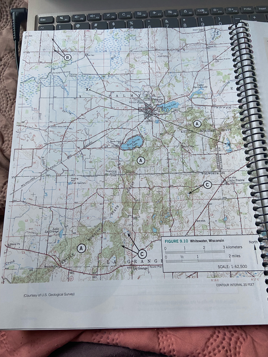
FIGURE 9.10 Whitewater, Wisconsin
North
3 kilometers
Creek
SKETTLE
GRAN GE
/2
1
2 miles
655
982
SA La Grangei Round Prain
SCALE: 1:62,500
983
R 16 E
R 17 E
CONTOUR INTERVAL 20 FEET
(Courtesy of U.S. Geological Survey)
MORAINE
STATE
FOREST

Transcribed Image Text:Use the Whitewater, Wisconsin topo map, p 160 in book
The southeast corner of the map contains
O the ground moraine
O the outwash plain
O eskers.
O lateral moraines.
Expert Solution
This question has been solved!
Explore an expertly crafted, step-by-step solution for a thorough understanding of key concepts.

This is a popular solution

Trending nowThis is a popular solution!

Step by stepSolved in 2 steps

Knowledge Booster

Recommended textbooks for you
- Applications and Investigations in Earth Science ...Earth ScienceISBN:9780134746241Author:Edward J. Tarbuck, Frederick K. Lutgens, Dennis G. TasaPublisher:PEARSON
 Exercises for Weather & Climate (9th Edition)Earth ScienceISBN:9780134041360Author:Greg CarbonePublisher:PEARSON
 Environmental ScienceEarth ScienceISBN:9781260153125Author:William P Cunningham Prof., Mary Ann Cunningham ProfessorPublisher:McGraw-Hill Education
  Earth Science (15th Edition)Earth ScienceISBN:9780134543536Author:Edward J. Tarbuck, Frederick K. Lutgens, Dennis G. TasaPublisher:PEARSON
 Environmental Science (MindTap Course List)Earth ScienceISBN:9781337569613Author:G. Tyler Miller, Scott SpoolmanPublisher:Cengage Learning
 Physical GeologyEarth ScienceISBN:9781259916823Author:Plummer, Charles C., CARLSON, Diane H., Hammersley, LisaPublisher:Mcgraw-hill Education,
Applications and Investigations in Earth Science ...
Earth Science
ISBN:9780134746241
Author:Edward J. Tarbuck, Frederick K. Lutgens, Dennis G. Tasa
Publisher:PEARSON
Exercises for Weather & Climate (9th Edition)
Earth Science
ISBN:9780134041360
Author:Greg Carbone
Publisher:PEARSON
Environmental Science
Earth Science
ISBN:9781260153125
Author:William P Cunningham Prof., Mary Ann Cunningham Professor
Publisher:McGraw-Hill Education
Earth Science (15th Edition)
Earth Science
ISBN:9780134543536
Author:Edward J. Tarbuck, Frederick K. Lutgens, Dennis G. Tasa
Publisher:PEARSON
Environmental Science (MindTap Course List)
Earth Science
ISBN:9781337569613
Author:G. Tyler Miller, Scott Spoolman
Publisher:Cengage Learning
Physical Geology
Earth Science
ISBN:9781259916823
Author:Plummer, Charles C., CARLSON, Diane H., Hammersley, Lisa
Publisher:Mcgraw-hill Education,