Applications and Investigations in Earth Science (9th Edition)
9th Edition
ISBN: 9780134746241
Author: Edward J. Tarbuck, Frederick K. Lutgens, Dennis G. Tasa
Publisher: PEARSON
expand_more
expand_more
format_list_bulleted
Question
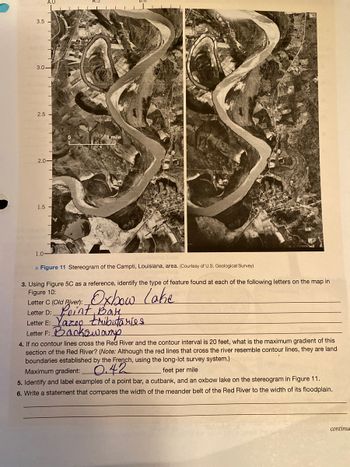
5. Identify and label examples of a point bar, a cutbank, and an oxbow lake on the stereograham and figure 11.

Transcribed Image Text:### Understanding River Features: Analyzing a Stereogram of the Red River, Campti, Louisiana
#### Figure 11: Stereogram of the Campti, Louisiana Area
This figure presents two stereographic images of a section of the Red River in Campti, Louisiana. The images are from the U.S. Geological Survey. A stereogram helps visualize geographical features in three dimensions when viewed with a stereoscope.
**Key Observations:**
- The river exhibits multiple meanders, with notable features including oxbow lakes and cutbanks.
- The left image displays a clearer oxbow lake at position "C."
#### Tasks and Analysis
**3. River Features Identification**
Using Figure 5C as a reference, identify the features marked by specific letters on the map in Figure 10:
- **Letter C (Old River):** Oxbow Lake
- **Letter D:** Point Bar
- **Letter E:** Yazoo Tributaries
- **Letter F:** Backswamp
**4. Gradient Calculation**
To find the maximum gradient of the Red River given a contour interval of 20 feet:
**Maximum Gradient:** 0.42 feet per mile
**5. Identification of River Features in the Stereogram**
Identify and label the following in the stereogram of Figure 11:
- **Point Bar:** Sediments deposited on the inside bends of meanders.
- **Cutbank:** The eroded outer bank on the outside of the meanders.
- **Oxbow Lake:** A U-shaped water body formed from a meander cutoff from the main river channel.
**6. Comparative Analysis Statement**
Write a statement comparing the width of the meander belt of the Red River to the width of its floodplain:
"The width of the meander belt, the zone in which the river freely migrates and creates meanders, is significantly smaller compared to the expanse of its floodplain, which is the broader area surrounding the river that floods during high discharge events."
This detailed analysis enhances understanding of river dynamics and geomorphological features, crucial for geographic studies and environmental planning.
Expert Solution
This question has been solved!
Explore an expertly crafted, step-by-step solution for a thorough understanding of key concepts.
This is a popular solution
Trending nowThis is a popular solution!
Step by stepSolved in 2 steps

Knowledge Booster
Recommended textbooks for you
 Applications and Investigations in Earth Science ...Earth ScienceISBN:9780134746241Author:Edward J. Tarbuck, Frederick K. Lutgens, Dennis G. TasaPublisher:PEARSON
 Exercises for Weather & Climate (9th Edition)Earth ScienceISBN:9780134041360Author:Greg CarbonePublisher:PEARSON
 Environmental ScienceEarth ScienceISBN:9781260153125Author:William P Cunningham Prof., Mary Ann Cunningham ProfessorPublisher:McGraw-Hill Education
 Earth Science (15th Edition)Earth ScienceISBN:9780134543536Author:Edward J. Tarbuck, Frederick K. Lutgens, Dennis G. TasaPublisher:PEARSON
 Environmental Science (MindTap Course List)Earth ScienceISBN:9781337569613Author:G. Tyler Miller, Scott SpoolmanPublisher:Cengage Learning
 Physical GeologyEarth ScienceISBN:9781259916823Author:Plummer, Charles C., CARLSON, Diane H., Hammersley, LisaPublisher:Mcgraw-hill Education,

Applications and Investigations in Earth Science ...
Earth Science
ISBN:9780134746241
Author:Edward J. Tarbuck, Frederick K. Lutgens, Dennis G. Tasa
Publisher:PEARSON

Exercises for Weather & Climate (9th Edition)
Earth Science
ISBN:9780134041360
Author:Greg Carbone
Publisher:PEARSON

Environmental Science
Earth Science
ISBN:9781260153125
Author:William P Cunningham Prof., Mary Ann Cunningham Professor
Publisher:McGraw-Hill Education

Earth Science (15th Edition)
Earth Science
ISBN:9780134543536
Author:Edward J. Tarbuck, Frederick K. Lutgens, Dennis G. Tasa
Publisher:PEARSON

Environmental Science (MindTap Course List)
Earth Science
ISBN:9781337569613
Author:G. Tyler Miller, Scott Spoolman
Publisher:Cengage Learning

Physical Geology
Earth Science
ISBN:9781259916823
Author:Plummer, Charles C., CARLSON, Diane H., Hammersley, Lisa
Publisher:Mcgraw-hill Education,