Applications and Investigations in Earth Science (9th Edition)
9th Edition
ISBN: 9780134746241
Author: Edward J. Tarbuck, Frederick K. Lutgens, Dennis G. Tasa
Publisher: PEARSON
expand_more
expand_more
format_list_bulleted
Question

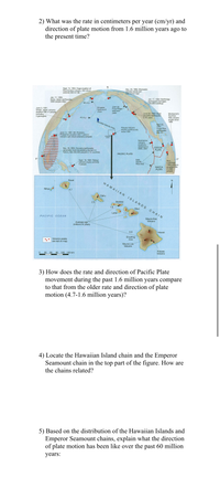
Transcribed Image Text:2) What was the rate in centimeters per year (cm/yr) and
direction of plate motion from 1.6 million years ago to
the present time?
Sept. 15, 1994: Huge eruption of
Kliuchevskoi volcano. Ash cloud
extends 565 km SE
Dec. 23, 1995: Shishaldin
volcano sends ash
over 10 km high
Jan. 17, 1995:
Kobe, Japan earthquake.
5000 people killed
Jan. 17, 1994: Northridge
earthquake damages
100,000 buildings
60 m.y.
June 3, 1991:
Unzen, Japan volcanic
eruption kills 41 people,
including-
3 geologists
Emperor
Seamount
chain
Juan de
Fuca Ridge
(red) and
plate
Montserrat's
Soufriere
Hills volcano
erupts since
1995
June 28, 1992: Most
powerful earthquake
in 40 years
40 m.y.
awaiian Islands chain
Kilauea Volcano
erupts continuously
since 1991
April 22,
1991:
Costa Rica
earthquake
kills 76
June 12, 1991: Mt. Pinatubo,
Philippines eruption kills 1 person;
volcanic ash cloud extensive (striped)
Enlarged
below
Submarine
volcanic
eruptions
observed in
2006, 2007
COCOS
PLATE
Dec. 26, 2004: Sumatra earthquake
generates most devastating tsunami in
history, kills 282,000 people in 12 countries
PACIFIC PLATE
0°
East
Pacific
Rise (red)
Sept. 19, 1994: Rabaul
volcano erupts and kills
5 people
Ruiz,
Colombia:
1994 volcanic
eruption kills
23,000
people
0°
NAZCA
PLATE
Kauai
HAWAII AN
Nihau
4.7
Oahu
ISLANDS
Molokai
2.5
1.6
Maui
CHAIN
Lanai
1.1
PACIFIC OCEAN
Mauna Kea
Volcano
Average age
(millions of years)
0.0
Hawai
Erupting
now
Volcanic peaks
are red on map.
Mauna Loa
Volcano
Kilauea
Volcano
30
60
90 120 150 km
3) How does the rate and direction of Pacific Plate
movement during the past 1.6 million years compare
to that from the older rate and direction of plate
motion (4.7-1.6 million years)?
4) Locate the Hawaiian Island chain and the Emperor
Seamount chain in the top part of the figure. How are
the chains related?
5) Based on the distribution of the Hawaiian Islands and
Emperor Seamount chains, explain what the direction
of plate motion has been like over the past 60 million
years:

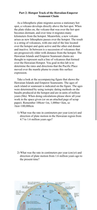
Transcribed Image Text:Part 2: Hotspot Track of the Hawaiian-Emperor
Seamount Chain
As a lithospheric plate migrates across a stationary hot
spot, a volcano develops directly above the hot spot. When
the plate slides on, the volcano that was over the hot spot
becomes dormant, and over time it migrates many
kilometers from the hotspot. Meanwhile, a new volcano
arises as new lithosphere passes over the hotspot. The result
is a string of volcanoes, with one end of the line located
over the hotspot and quite active and the other end distant
and inactive. In between is a succession of volcanoes that
are progressively older with distance from the hotspot. The
Hawaiian Islands and Emperor Seamount chains are
thought to represent such a line of volcanoes that formed
over the Hawaiian Hotspot. You goal in this lab is to
determine the rates and directions that the Pacific Place
moved over the mantle plume to create this surface
expression.
Take a look at the accompanying figure that shows the
Hawaiian Islands and Emperor Seamounts. The ages of
each island or seamount is indicated on the figure. The ages
were determined by using isotopic dating methods on the
basalts produced at the hotspot and are in units of million
years (Ma). When doing calculations please show all your
work in the space given (or on an attached page of scrap
paper). Remember 100cm=1m, 1,000m=1km, so
1km=100,000cm
1) What was the rate in centimeters per year (cm/yr) and
direction of plate motion in the Hawaiian region from
4.7 to 1.6 million years ago?
2) What was the rate in centimeters per year (cm/yr) and
direction of plate motion from 1.6 million years ago to
the present time?
Sept. 15, 1994: Huge eruption of
Kliuchevskoi volcano. Ash cloud
extends 565 km SE
Dec. 23, 1995: Shishaldin
volcano sends ash
Over 10 km high
Jan. 17, 1995:
Kobe, Japan earthquake.
5000 people killed
Jan. 17, 1994: Northridge
earthquake damages
100,000 buildings
60 m.y.
Juan de
Fuca Ridge
(red) and
plate
Emperor
Seamount
June 3, 1991:
Unzen, Japan volcanic
eruption kills 41 people,
including-
3 geologists
chain
June 28, 1992: Most
powerful earthquake
in 40 years
Montserrat's
Soufriere
Hills volcano
erupts since
1995
40 m.y.>
Fawaian Islands chain
Kilauea Volcano
erupts continuously
since 1991
April 22,
1991:
Costa Rica
earthquake
kills 76
June 12, 1991: Mt. Pinatubo,
Philippines eruption kills 1 person;
volcanic ash cloud extensive (striped)
Enlarged
Submarine
volcanic
eruptions
observed in
2006, 2007
Dec. 26, 2004: Sumatra earthquake
generates most devastating tsunami in
COCOS
PLATE
Expert Solution
This question has been solved!
Explore an expertly crafted, step-by-step solution for a thorough understanding of key concepts.
This is a popular solution
Trending nowThis is a popular solution!
Step by stepSolved in 2 steps

Knowledge Booster
Recommended textbooks for you
 Applications and Investigations in Earth Science ...Earth ScienceISBN:9780134746241Author:Edward J. Tarbuck, Frederick K. Lutgens, Dennis G. TasaPublisher:PEARSON
 Exercises for Weather & Climate (9th Edition)Earth ScienceISBN:9780134041360Author:Greg CarbonePublisher:PEARSON
 Environmental ScienceEarth ScienceISBN:9781260153125Author:William P Cunningham Prof., Mary Ann Cunningham ProfessorPublisher:McGraw-Hill Education
 Earth Science (15th Edition)Earth ScienceISBN:9780134543536Author:Edward J. Tarbuck, Frederick K. Lutgens, Dennis G. TasaPublisher:PEARSON
 Environmental Science (MindTap Course List)Earth ScienceISBN:9781337569613Author:G. Tyler Miller, Scott SpoolmanPublisher:Cengage Learning
 Physical GeologyEarth ScienceISBN:9781259916823Author:Plummer, Charles C., CARLSON, Diane H., Hammersley, LisaPublisher:Mcgraw-hill Education,

Applications and Investigations in Earth Science ...
Earth Science
ISBN:9780134746241
Author:Edward J. Tarbuck, Frederick K. Lutgens, Dennis G. Tasa
Publisher:PEARSON

Exercises for Weather & Climate (9th Edition)
Earth Science
ISBN:9780134041360
Author:Greg Carbone
Publisher:PEARSON

Environmental Science
Earth Science
ISBN:9781260153125
Author:William P Cunningham Prof., Mary Ann Cunningham Professor
Publisher:McGraw-Hill Education

Earth Science (15th Edition)
Earth Science
ISBN:9780134543536
Author:Edward J. Tarbuck, Frederick K. Lutgens, Dennis G. Tasa
Publisher:PEARSON

Environmental Science (MindTap Course List)
Earth Science
ISBN:9781337569613
Author:G. Tyler Miller, Scott Spoolman
Publisher:Cengage Learning

Physical Geology
Earth Science
ISBN:9781259916823
Author:Plummer, Charles C., CARLSON, Diane H., Hammersley, Lisa
Publisher:Mcgraw-hill Education,